Mediocre period of swell ahead

Western Australian Surf Forecast by Craig Brokensha (issued Monday April 1st)
Best Days: South West magnets Wednesday, Thursday once the swell arrives and Friday once the swell arrives ahead of sea breezes
Features of the Forecast (tl;dr)
- Small pulses of background S/SW swell for the coming days
- Strong SE tending E/SE winds tomorrow, then S/SE later
- Strong E/SE winds Wed, tending S/SE
- Mod-fresh E/NE winds Thu, tending lighter N into the PM
- Small, building S/SW swell Thu, easing Fri
- Small-moderate sized, inconsistent SW groundswell building Fri, peaking overnight, easing Sat
- Moderate E/NE winds Fri AM ahead of sea breezes
- Gusty S/SE-SE winds Sat
- Small-moderate swells for Sun through all of next week with morning SE-E/SE winds
Recap
Friday afternoon's building W/SW groundswell peaked Saturday morning with mid-period energy also in the mix, coming in at a fairly clean 6-8ft in the South West with variable offshore winds, 3ft across Mandurah and 2-3ft in Perth.
The swell eased back through yesterday with the metro locations fairing best wind wise, bumpy-choppy across the South West and best in protected spots.
Today the swell is back to the tiny range across the metro beaches, best across the South West magnets though on the smaller side of the coin.

Great conditions and swell Saturday AM
This week and next (April 2 - 12)
The coming week looks small in general, but not flat across the South West, with late forming frontal activity to our south-southwest due to provide small pulses of mid-period S/SW swell to the magnets.
In general it'll be small though and not topping 3ft tomorrow through to Thursday, smaller in the morning Thursday and also Friday morning.
Perth and Mandurah will become tiny to flat.
Conditions look tricky for the south magnets tomorrow with a strong SE tending E/SE breeze , shifting S/SE into the afternoon, with better strong but easing E/SE winds on Wednesday, shifting S/SE into the mid-afternoon.
Thursday looks the cleanest and best for the south magnets with the building swell and a moderate to fresh E/NE breeze, easing and tending more N'ly into the afternoon.
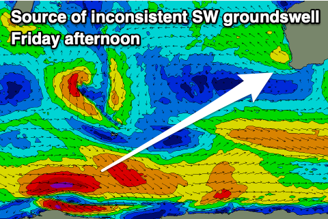
Friday should see similar E/NE morning winds but a temporary low point in swell ahead of the next pulse of swell, which looks to be a healthy SW groundswell into the afternoon. The source is a slim, polar fetch of gale to severe-gale W'ly winds currently around the Heard Island region. The swell will be inconsistent but should build to 4-5ft across the South West magnets, easing back from 4ft Saturday morning with poor, gusty S/SE-SE winds.
Unfortunately the longer term outlook remains relatively slow with persistently weak polar frontal activity moving across the Heard Island region not expected to top 3-4ft across the South West magnets on the weekend and early next week (more so 4ft and tiny to the north).
Winds look to generally be out of the south-eastern quadrant, favouring the small wave breaks.
Longer term the Southern and Indian Oceans remain void of any major frontal activity, but we'll have another looks at this Wednesday and Friday.