Easing surf ahead of larger energy into the weekend

Western Australian Surf Forecast by Craig Brokensha (issued Monday March 25th)
Best Days: South West magnets tomorrow for the keen, Thursday and Friday mornings in the South West, Saturday morning, Sunday morning
Features of the Forecast (tl;dr)
- Fading S/SW swell tomorrow with light E/SE-SE winds ahead of sea breezes
- Fun mid-period SW swell Thu with variable tending light offshore winds ahead of sea breezes
- Large W/SW groundswell building late Fri, peaking Sat AM
- Light S/SE tending strong S/SW-SW winds Sat, gusty SE tending S/SE Sun
Recap
Friday's swell eased off into Saturday with some good, clean surf to 4-5ft on the magnets in the morning, small and windy yesterday. Perth and Mandurah were tiny.
Today, our flukey pulse of S/SW swell has come in nicely with clean conditions and 3-4ft sets on the magnets.
This week and weekend (Mar 26 - 31)
Today's small lift in S/SW swell is due to fade through tomorrow with 3ft sets on the South West magnets, tiny elsewhere.
Conditions should be nice and clean with a light E/SE-SE offshore ahead of sea breezes.
It then isn't until later in the week that we see any new swell arriving, with a small lift in mid-period SW swell due on Thursday ahead of some larger W/SW groundswell Friday afternoon and Saturday morning.
Thursday's swell will be generated by a healthy pre-frontal fetch of strong W/NW winds that are currently just east of the Heard Island region, while behind this, stronger W/SW gales are being generated, linked to the groundswell later week.
But back to the mid-period energy and a fun 4ft or so of swell is due in the South West, tiny to the north and with a variable breeze, likely light offshore ahead of sea breezes.
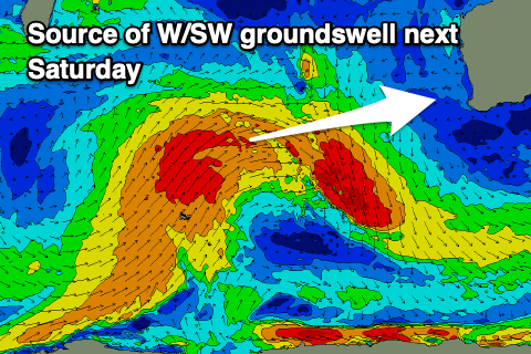
Now, as touched on in Friday's update, we'll see a tricky mixed W/SW groundswell for Friday/Saturday, thanks to a northward projecting polar frontal system that will be a little disjointed. In saying that, gale-force winds will persist throughout the initial stages as it pushes north and then east, generating a large W/SW groundswell that's only due to arrive later Friday but peak Saturday morning.
Our reinforcing pulse of closer-range SW energy from a secondary intensification on the back of the progression now looks minimal in size, with a much weaker follow up frontal system due.
With this the main source of energy will be the W/SW groundswell, peaking at 8ft across the South West Saturday morning, 3ft in Mandurah and 2-3ft across Perth.
Winds on Friday morning ahead of the swell look E/NE-NE in the South West, shifting W'ly through the day with light S/SE winds on Saturday morning, shifting strong S/SW-SW into the afternoon. Sunday will see gusty SE winds as the swell backs from a smaller 5-6ft across the South West with 2ft waves in Mandurah and 1-2ft surf across Perth.
Unfortunately longer term, there's nothing too major on the cards until late next week, with a period of inactivity due in the Indian Ocean. More on this Wednesday.