Easing surf on the weekend, large next weekend

Western Australian Surf Forecast by Craig Brokensha (issued Friday March 22nd)
Best Days: The South West tomorrow morning, and the magnets Sunday morning, the South West south magnets Monday morning, protected spots next Saturday, next Sunday
Features of the Forecast (tl;dr)
- Easing SW groundswell tomorrow with strong E/SE winds, easing ahead of mid-late PM S/SE-SE winds
- Smaller Sun with fresh E/NE tending NE then W/NW-NW winds
- Flukey S/SW swell Mon with E/SE tending E/NE then NE winds ahead of sea breezes
- Easing swell Tue with S/SE-SE tending S/SW winds
- Large W/SW groundswell building later Fri, peaking Sat, mixed in with a SW groundswell
- Gusty S/SE winds Sat, E/SE-SE Sun AM
Recap
The swell was still in the 3-4ft range across the South West yesterday morning with strong offshore winds and tiny options to the north.
Today, our inconsistent SW groundswell is just that, but with a little bump in size. It's getting into some breaks better than others with 4-5ft sets across those sucking in the energy (now with the odd 6ft set). Perth and Mandurah are still tiny.

Slow but good sized sets today
This weekend and next week (Mar 23 - 29)
Today's swell is due to ease back through tomorrow but still come in at 3-5ft across the magnets in the morning across the South West though tiny to the north. It'll be smaller again on Sunday but surfable across the South West magnets.
Strong E/SE winds are due tomorrow morning, easing and then tending S/SE-SE through the afternoon with fresh E/NE winds on Sunday, tending NE and then W/NW-NW into the afternoon.
Looking at our flukey pulse of S/SW groundswell for Monday, and it still looks just that, with it favouring the South Coast over the South West. A late forming polar low today will generate a fetch of gale to severe-gale W/SW winds on the polar shelf, very late in our southern swell window.
The models are picking up the swell though and with that we should see a boost in size to 4ft across the magnets in the South West, tiny to the north.
Winds are due to improve through the morning, being E/SE early then shifting light E/NE and then NE, favouring those south magnets before sea breezes kick in.
Tuesday looks less than ideal as the swell eases with an E/SE-SE offshore and fading 3ft sets. The surf will then continue to fade and bottom out through Wednesday and Thursday, ahead of some new W/SW swell energy building into Friday, peaking Saturday.
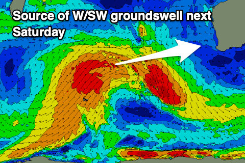
Now, as touched on in the last couple of updates, the frontal progression linked to this W/SW swell energy is strong but a little unconsolidated, with back to back polar frontal systems forecast to project north, high into the Indian Ocean.
An initial polar frontal system developing west of the Heard Island region Sunday, should project a weakening fetch of gale to severe-gale W/SW-SW tending S/SW winds north, being aimed mostly towards Indonesia. This will limit the size for our regions a little, but the eastward movement looks healthy, with a moderate-large sized, inconsistent W/SW groundswell due to arrive Friday, build slowly through the day and peak Saturday.

At the same time, a good reinforcing pulse of more consistent SW groundswell is due, generated by a secondary front projecting towards us Wednesday and Thursday, to the south-west of the state.
Both swell should combine to offer 8ft sets across the South West with 3ft waves in Mandurah and 2-3ft surf across Perth Saturday, easing into the afternoon and further Sunday.
Winds look gusty out of the S/SE on Saturday, favouring protected spots, E/SE-SE on Sunday morning as the swell fades, but we'll review this Monday. It's a bit slow following this, but we'll go over the charts again Monday. Have a great weekend!