Fun swell for Friday, then slowish until later next week

Western Australian Surf Forecast by Craig Brokensha (issued Wednesday March 20th)
Best Days: Friday, Saturday and Monday morning in the South West, later next week onwards
Features of the Forecast (tl;dr)
- Moderate E/NE-E winds tomorrow but small
- Late increase in inconsistent SW groundswell tomorrow, peaking Fri with strong E/SE winds, easing
- Easing swell Sat with strong E/SE winds, easing
- Smaller Sun
- Small pulse of S/SW swell Mon with E/SE tending S/SW winds, easing Tue with similar winds
- Larger W/SW-SW swell later next week and weekend
Recap
Yesterday offered great waves in the morning with the building SW-S/SW groundswell seen into Monday afternoon and evening holding a good 6ft across the South West, 2ft to occasionally 3ft across Mandurah and 2ft in Perth.
Today is smaller and windier with clean but tricky 3-4ft waves in the South West, tiny to the north.
This week and next (Mar 21 - 29)
Tomorrow looks to be a lay day as the swell bottoms out under a morning E/NE-E breeze. A trough will bring sea breezes and then strong S/SE-SE winds into the evening, with a high following it into Friday.
This should swing winds more E/SE but with strength on Friday morning when our new, inconsistent SW groundswell fills in.

As touched on the last couple of updates, this swell was generated by an initially strong and distant polar low that formed south-east of South Africa. It's since weakened but pushed further east, with the swell due to come in at an inconsistent 6ft across the South West magnets Friday with 1.5ft waves to the north.
Saturday should see slowly easing surf from 4-5ft across the South West, tiny to the north and with strong E/SE winds, easing into the afternoon.
Sunday looks smaller and with E/NE tending N/NW winds.
Into Monday a small pulse of mid-period S/SW swell is due, generated by a late forming polar low (in our swell window) on Friday. It'll generate a fetch of W/SW gales but very late in our swell window, with a slight bump in size due across the South West Monday to 3-4ft, tiny to the north.
It looks like we'll see the favourable conditions continuing with a light E/SE offshore, similar Tuesday morning but with fading surf.
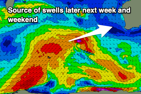
As touched on in Monday's update, we're looking at some larger surf into the end of next week and weekend, thanks to a strong node of the Long Wave Trough moving in west of us.
Unfortunately the strength of each cold front pushing up towards us as this stage looks to be nothing of any real significance and slightly jumbled. With this a mix of largish swells are due with a bit of west in them, favouring metro locations.
It's hard to put a size on things just yet but surf to 8ft is likely in the South West, 2-3ft to the north but we'll review this Friday.