Average outlook for the coming days, better early next week

Western Australian Surf Forecast by Craig Brokensha (issued Wednesday March 13th)
Best Days: Monday selected spots, Tuesday
Features of the Forecast (tl;dr)
- Fading surf over the coming days with strong E/SE tending S/SE winds tomorrow, mod-fresh E/SE winds ahead of sea breezes Fri
- Small, inconsistent mid-period W/SW swell building Sat with fresh E/NE winds ahead of sea breezes
- Moderate sized, inconsistent mid-period W/SW swell building Sun with gusty S tending stronger S/SW winds
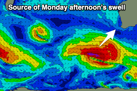
- Strong S/SE-SE winds Mon, with a large, building SW-S/SW groundswell
- Easing S/SW groundswell Tue with strong E/SE tending SE winds
- Smalle Wed
Recap
Yesterday's large swell with offshore winds came in very nicely with clean, pumping 8-10ft surf across the South West as winds remained favourable until mid-afternoon. The swell built to the north and reached 2-3ft through the day across Mandurah and a slow 2ft in Perth.
This morning the swell was half the size but still clean and easing from the 5ft range in the South West, tiny to the north.

Yesterday AM. Spot the head at the base of the wave out the back
This week and next (Mar 14 - 22)
Down, down, down. The surf will fade over the coming days with no significant new swell energy due into the end of the week.
Winds will be tricky tomorrow and strong from the E/SE, tending more S/SE into the afternoon with moderate to fresh E/SE winds Friday morning ahead of sea breezes.
Into the weekend, we've got building levels of mid-period W/SW swell energy, with an initial small pulse on Saturday ahead of a stronger increase through Sunday, peaking into the afternoon.
These swells have been generated by a slow moving frontal progression that fired up to the south-east of South Africa, with it now weakening in the Heard Island region.
It'll be inconsistent but Saturday's first pulse should build to 3ft across the South West, with the secondary pulse for Sunday reaching 4-5ft into the afternoon. Perth and Mandurah look to remain tiny and unsurfable.
E/NE winds should create clean conditions on Saturday morning ahead of sea breezes with Sunday now not expected to see early variable winds. Instead a trough will move in earlier, bringing fresh S'ly tending S/SW winds.
Winds should improve into Monday, swinging more S/SE-SE but remaining strong along with a new pulse of building S/SW groundswell.
This swell will be generated by a stronger frontal system strengthening while moving east through our swell window, generating a fetch of gale to severe-gale W'ly winds in our south-western to southern swell windows.
The swell should spike to 6-8ft into the afternoon, easing back from 5ft or so Tuesday morning with 2ft sets in Mandurah, 1-2ft across Perth, tiny Tuesday.
Winds will shit more E/SE on Tuesday as the swell eases, strong in nature with it continuing to drop in size until later in the week.
This is when a large, long-period SW groundswell is due, generated by a strong polar low firing up west of the Heard Island region. We'll have a closer look at this on Friday though.
Otherwise, we'll note a likely tropical cyclone forming off the north-west on the weekend, tracking south-west, but when it moves into our swell window it doesn't appear to produce any decent swell generating winds. More on this Friday.
Comments
Winds will shit more on Tuesday. Perfect