Great tomorrow, slower thereafter

Western Australian Surf Forecast by Craig Brokensha (issued Monday March 11th)
Best Days: Tomorrow, Wednesday morning in the South West, early Sunday in the South West
Features of the Forecast (tl;dr)
- Large S/SW groundswell for tomorrow AM, easing with E/SE-SE winds ahead of mid-late afternoon sea breezes
- Easing swell Wed with similar, but weaker winds and earlier sea breezes
- Small Thu with gusty SE winds ahead of strong sea breezes
- Inconsistent, small W/SW swell building Sat with fresh E/NE winds ahead of weak sea breezes
- Better W/SW swell for Sun, peaking in the PM with variable tending strong S/SW winds
- Easing swell Mon with gusty S/SE-SE winds ahead of sea breezes
Recap
The swell came up quite solid on Saturday thanks to the upgrade in the strength of Friday's trough, come low, with windy 6ft+ waves in the South West, better across Perth and Mandurah to 2ft.
Sunday offered much cleaner conditions with plenty of size hanging in at 4-6ft across the South West, though slower and still 1-2ft to the north. This morning the surf is smaller with clean conditions which are still holding across metro locations.
This week and weekend (Mar 12 - 17)
Later today we might see the forerunners of a large S/SW groundswell that's due to peak tomorrow morning across the South West arriving. The swell was generated by a strong polar low firing up east of the Heard Island region on the weekend, generating a fetch of severe-gale W/SW winds through our southern swell window.
Good 8ft+ sets are due across the South West magnets, 2-3ft in Mandurah and 2ft across Perth under gusty SE tending E/SE winds, giving into mid-afternoon sea breezes.
The swell should start to ease through the day, with Wednesday coming in smaller and to 4-5ft, down to 3ft during the day. Perth and Mandurah look to become small to tiny on Wednesday. Winds look similar to tomorrow but weaker in strength with sea breezes kicking in earlier as a result.
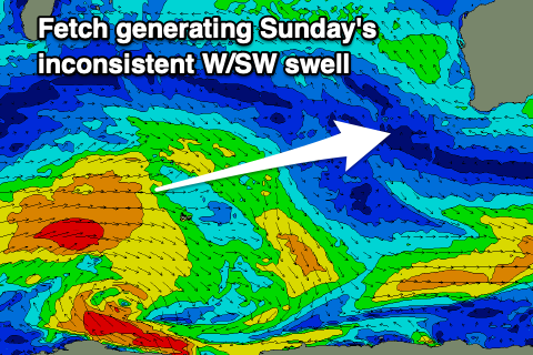
Our next increase in swell looks to arrive Saturday afternoon, with a peak due Sunday afternoon. The source being a distant, slow moving fetch of strong W/SW winds, to the south-east of South Africa over the coming days.
An initial pulse of swell is due Saturday building to 3ft or so in the South West, with Sunday's being much better and reaching 4-5ft on the sets. Perth and Mandurah unfortunately don't look to get over 1ft or so.
E/NE winds should create clean conditions on Saturday morning, variable into the mid-afternoon ahead of late sea breezes, dicey Sunday and likely variable early before a trough brings a strengthening S'ly change.
Longer term we're looking at a possible better mid-period SW swell for early next week but we'll have a closer look at this on Wednesday.
Comments
Crikey.