Fun surf developing from late week

Western Australian Surf Forecast by Craig Brokensha (issued Monday November 6th)
Best Days: Wednesday morning in the South West, protected spots Friday, Saturday morning, Sunday morning in the South West
Features of the Forecast (tl;dr)
- Small tomorrow with fresh S/SE tending strong S/SW winds
- Small lift in mid-period swell Wed with light E/SE tending strong S/SW winds
- Easing surf Thu with strong SW tending S/SW winds
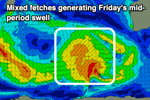
- Moderate sized + mid-period SW swell filling in Fri, peaking in the PM with gusty S/SE tending strong S/SW winds
- Easing swell slowly Sat with gusty SE tending S/SE winds
- Smaller Sun with strong E/SE tending S/SE winds
Recap
A small to tiny start to Saturday while our new swell for Sunday came in nicely with a lift in size under offshore winds. The South West kicked to 4-5ft on the sets while to the north, the surf remained tiny.
Today, onshore winds have moved in across the South West while Mandurah and Perth were offering tiny levels of windswell.
This week and weekend (Nov 4 - 10)
The coming days look generally average with small levels of background swell due to pad out the exposed breaks in the South West, peaking Wednesday though only to 3-4ft+ before easing Thursday.
Winds look less than ideal tomorrow, fresh from the S/SW, tending stronger S/SW through the afternoon, while Wednesday looks fun with a light E/SE offshore ahead of sea breezes.
Now, moving into Thursday and an approaching frontal progression will see strong SW tending S/SW winds develop across the South West (S/SE early for a period to the north) along with the low point in swell, but on Friday a good kick in mid-period SW swell is due, generated by the progression itself.
A relatively weak but slow moving polar low is currently forming around the Heard Island region, with it forecast to project a slow moving fetch of strong W/SW-SW winds towards us over the coming days.
The low will move east, under us while weakening Thursday, but a final front will be drawn up on its back, generating an additional boost in energy, slowing the easing trend on Saturday.
All in all the swell looks to be generally weak and moderate + sized, with building sets to 6ft+ across the South West magnets into the afternoon, 2ft+ Mandurah and Perth.
Winds won't be ideal but favourable for protected spots with a S/SE breeze in the morning strengthening and tending S/SW into the afternoon, while Saturday should see better SE winds in the morning and easing surf from 6ft and 2ft+ respectively.
As touched on in last week's outlook, stronger E/SE winds are due into Sunday with a further drop in swell and there's nothing too significant swell wise to follow up Friday/Saturday's energy. Small reinforcing S/SW pulses are on the cards for early next week along with favourable E/SE winds, but we'll have a closer look at this on Wednesday.