Fun tomorrow, with a window early next week

Western Australian Surf Forecast by Craig Brokensha (issued Friday October 27th)
Best Days: Tomorrow morning, Tuesday morning
Features of the Forecast (tl;dr)
- Moderate sized mid-period SW swell for tomorrow AM, easing and smaller Sun
- E/SE-E winds Sat AM, strengthening from the SW into the PM
- SW winds Sun (variable early to the north)
- Moderate sized mid-period S/SW swell building Mon with gusty S/SE winds (tending strong S/SW into the PM to the north)
- Easing S/SW swell strong E/SE tending S/SW winds
- Smaller Wed with mod-fresh E/SE-SE tending S/SW winds
Recap
The surf bottomed out into yesterday morning, but a small lift in weak swell has been seen across all coasts today though with no size or period attached to it. The South West was choppy and to 4ft, 1-2ft further north with cleaner conditions.
This weekend and next week (Oct 28 - Nov 3)
Looking at the weekend and a better pulse of mid-period SW swell is due tomorrow across the South West with a slow moving, but relatively weak mid-latitude low generating a kick in size to 4-6ft across the South West while the metro locations hang in around 1-2ft.
The main plus for tomorrow are the local winds with offshore E/SE-E wind due in the morning ahead of a strengthening SW breeze into the afternoon, so surf before lunch.
Sunday unfortunately looks poor as the trough bringing tomorrow afternoon’s change leaves lingering SW winds (variable early to the north) but tiny.
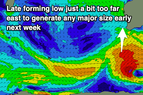
Moving into next week we’ve got our secondary pulse of S/SW swell due, generated by the late forming Southern Ocean frontal progression, south-west of us tomorrow.
It looks a little too late to generate any major size with strong SW winds due to produce a moderate sized, mid-period S/SW swell that should build through the day and peak into the afternoon. The swell will have a touch of longevity and ease slowly through Tuesday.
The South West should reach 4-6ft on the magnets while Mandurah may see 1-2ft sets, tiny and to 1-1.5ft across Perth.
Winds will be poor and average out of the S/SE on Monday, holding all day in the South West while tending S/SW to the north, while Tuesday looks better but smaller with gusty E/SE offshore winds and easing sets from 4-5ft+ across the South West, tiny to the north.
The surf will continue to ease Wednesday with slightly less favourable E/SE-SE winds, similar Thursday but with less size again.
Following this the outlook remains slow so make the most of tomorrow morning and early next week. Have a great weekend!