Fun surf days into next week

Western Australia Surf Forecast by Craig Brokensha (issued Friday 6th September)
Best Days: Perth and Mandurah Saturday morning, Monday morning South West, Tuesday morning in the South West, Wednesday morning, Thursday morning
Recap
Background swells to 3-4ft across the South West magnets with offshore winds in the mornings, tiny to the north and hot.
This weekend and next week (Dec 7 - 13)
There's been no real change to the mid-period W/SW swell due over the weekend, but also no change to the winds. There is a little reinforcing W/SW swell now on the cards for Sunday providing better waves in Perth and Mandurah.
Tomorrow's swell should kick to 4-5ft+ across the South West tomorrow, 1ft to occasionally 2ft in Mandurah and 1-1.5ft in Perth, but a morning NW-N/NW breeze will strengthen and swing more W'ly.
 Lingering onshore S/SW winds are due into Sunday across the South West, S/SE early to the north and a weak front moving in from the west tomorrow will project a tight fetch of strong W'ly winds towards us.
This will generate an additional W'ly windswell to the mix Sunday favouring Perth and Mandurah with sets to 2ft, worth a morning paddle.
Monday is still looking nice and clean across most locations as winds swing E/SE around Margs, SE further north with a mix of easing swells from 3-4ft in the South West, 1ft+ further north.
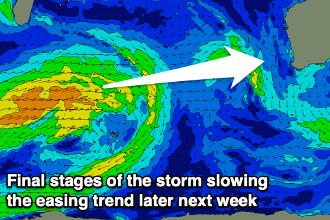
A low point in swell is expected on Tuesday morning but the long-period fore-runners of a new W/SW groundswell should be starting to show, building more noticeably into the afternoon and peaking overnight if not early Wednesday.
This was generated by a strong but distant storm forming south-east of South Africa during the middle of the week, with it now weakening north-west of Heard Island. It will have some longevity, slowing the easing trend a little but we'll be on a downwards trend in size and power from Wednesday afternoon and more so Thursday.
Margaret River should build slowly towards 4-5ft+ by dark and peaking Wednesday morning to 5-6ft on the sets. Mandurah should see 1-2ft sets, with Perth similar but likely a little less consistent.
Winds from Tuesday look great with a morning SE breeze across all locations (S/SE at times in the South West) giving into sea breezes, and then SE Wednesday morning, and then a better E/SE offshore Thursday as the swell eases. Friday will be clean again with an E/NE offshore but the swell will be on the way out and only dropping from 3ft+.
Longer term we may see a small new mid-period W/SW swell next weekend and with light local winds but we'll have a closer look at this Monday. Have a great weekend!