Easing swell with OK winds, fun weekend

Western Australia Surf Forecast by Craig Brokensha (issued Monday 22nd October)
Best Days: Tuesday morning, early Wednesday morning Perth and Mandurah, keen surfers Thursday morning around Margs, Saturday and Sunday across Margs
Recap
Terrible conditions across the South West all weekend with building levels of swell with an OK window of conditions around Perth and Mandurah early Saturday for keen surfers, poor yesterday.
Today our oversized SW groundswell has filled in across the South West, a little slow in Perth and Mandurah but now on the build though with onshore winds.
Today’s Forecaster Notes are brought to you by Rip Curl
This week and weekend (Oct 23 - 28)
Today's oversized SW groundswell is expected to peak this afternoon and ease from this evening through tomorrow and Wednesday, further into the end of the week.
This easing trend will be slowed somewhat by a weak mid-period W/SW swell filling in Thursday but mainly across the South West, with Perth and Mandurah likely to become tiny.
Size wise Margs should still see 8ft sets tomorrow morning, with 3ft waves in Mandurah and 2-3ft sets in Perth with our early offshore wind still expected.
 Margs will see a dawn E/NE offshore, tending NE through the morning and then NW, freshening from early-mid afternoon so there should be plenty of time to get a wave in, though it probably won't be pumping. Perth and Mandurah should see E/SE tending E/NE winds ahead of sea breezes.
Unfortunately as the swell continues to ease on Wednesday the South West looks to see NW onshore breezes, swinging SW through the day as the mid-latitude low linked to Thursday's weak reinforcing swell pushes in from the west.
Perth and Mandurah should see early variable breeze but smaller 2ft sets (1-2ft Perth).
Thursday isn't great either with winds improving though holding out of the S/SE with tiny waves in Perth and Mandurah and weak 4ft sets in Margs.
Friday looks dicey with lingering onshore breezes likely across the South West and no new swell energy until later in the day and more so Saturday.
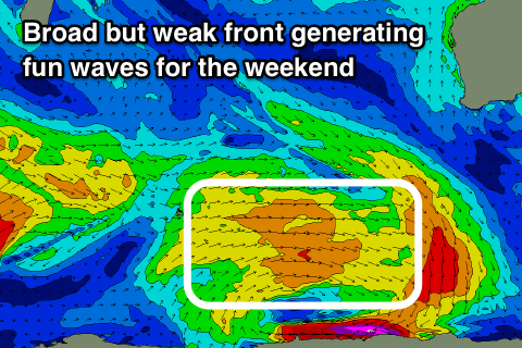
This mid-period swell is forecast to be generated by a weak polar fetch of broad W/SW winds, behind a poorly aligned pre-frontal gale-force N/NW fetch.
No major size is expected though the South West should pick up to 4-5ft on the magnets and persist through Sunday, with another similar sized reinforcing pulse for Monday.
Winds should improve and swing offshore each morning over the weekend with afternoon sea breezes, back to the S/SE early next week, but more on this Wednesday.
Longer term we may see a slightly bigger but inconsistent W/SW groundswell for Tuesday next week with better winds, though we'll review this Wednesday.