Poor weekend, large swell next week

Western Australia Surf Forecast by Craig Brokensha (issued Friday 12th October)
Best Days: Monday morning Perth and Mandurah, Tuesday all coasts, early Wednesday all coasts
Recap
Good clean easing waves across the South West swell magnets yesterday morning, small in Mandurah and to 1-2ft, tiny in Perth.
This morning the swell has bottomed out and with onshore winds across all locations.
Today’s Forecaster Notes are brought to you by Rip Curl
This weekend and next week (Oct 13 - 19)
The coming weekend will be poor across all locations with the swell remaining small and onshore tomorrow with a NW tending W/NW breeze across the South West, likely N/NE early in Perth and Mandurah but with no size.
Our large mix of building W/SW groundswell and stormy windswell have changed a bit, with the initial polar low coming in as forecast, while the secondary system will be much much weaker and project more northward and into Perth.
What we can expect is still a stormy increase in swell to 3ft across Perth and Mandurah Sunday with strong W/SW tending SW winds, while Margs will build to 6ft+ later in the day but with those onshore winds.
The mid-latitude front will continue east Monday but the South West looks to remain onshore and out of the NW, tending W/NW through the day with easing levels of groundswell from 6ft+. Perth and Mandurah should see a morning E/NE offshore and fun easing surf from 2-3ft.
 We then look ahead to our much larger and stronger W/SW groundswell due through the middle of the week.
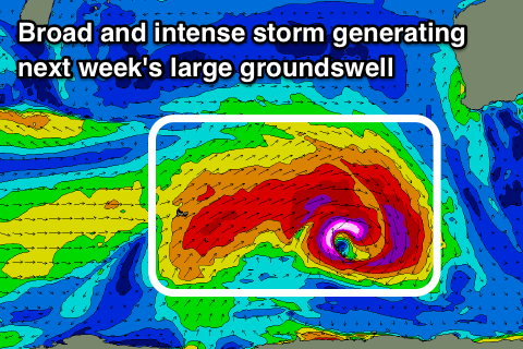
Tomorrow we should see a vigorous storm develop just north of the Heard Island region, producing a pre-frontal fetch of severe-gale W/NW winds, immediately followed by severe-gale to storm-force W/SW winds.
This will generate a large, consistent long-period W/SW groundswell that is due to build Tuesday and peak into the mid-late afternoon.
A rapid increase in size to 8-10ft should be seen across the South West, 3ft in Mandurah and 2-3ft in Perth with a morning E/NE offshore across all locations, variable into the afternoon with possible weak sea breezes.
Wednesday looks good early as well as the swell eases with dawn E/NE breezes, quickly giving into NW winds as more mid-latitude frontal systems approach from the west.
These mid-latitude fronts will bring large onshore mid-period swells through later next week and the weekend, with winds not expected to ease off until the swell is well on the ease. We'll have a closer look at this on Monday though. Have a great weekend (though forget surfing).