Fun swells, becoming stronger with favourable winds

Western Australia Surf Forecast by Craig Brokensha (issued Friday 21st September)
Best Days: Swell magnets across the South West Saturday and Sunday and Monday morning,, Mandurah Saturday and Sunday mornings, Tuesday onwards
Recap
Good fun surf across all locations yesterday morning with offshore winds and surf in the 4ft+ range across the South West, 2ft in Mandurah and Perth.
This morning a new SW swell has kicked up a bit more size across all locations, with light variable winds and clean 4-6ft sets across the South West, 2ft+ in Mandurah and 2ft in Perth again.
Today’s Forecaster Notes are brought to you by Rip Curl
This weekend and next week (Sep 22 - 28)
We've got good winds and fun waves due over the weekend across swell magnets mostly in the South West, with today's pulse of SW swell easing through this afternoon and into tomorrow morning, replaced by a new mid-period S/SW swell into the afternoon.
This swell started to be generated yesterday by a broad but relatively weak polar front to our south-west, with a fetch of strong to sub-gale-force SW tending W/SW winds being produced in our southern swell window.
Looking at tomorrow morning though and an E/NE offshore should create clean conditions with surf back to the 4ft range across the South West, 1-2ft in Mandurah and 1-1.5ft in Perth.
Winds will go variable and then likely weak sea breezey with the new building S/SW swell, reaching 4-5ft across the South West, maintaining similar sized surf further north.
Sunday should be fun as the swell eases from 3-5ft in the South West, 1ft to maybe 2ft in Mandurah and tiny to the north under a light morning E'ly offshore across all spots, tending variable and then S/SW into the afternoon.
Monday will be great again but smaller and best across the South West swell magnets with a morning offshore and afternoon sea breezes.
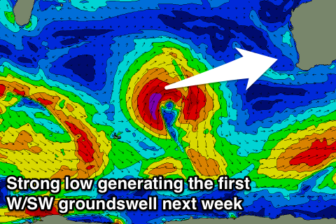 Our first pulse of long-period W/SW groundswell for early next week has been upgraded a little, with an intense mid-latitude forming in the central Indian Ocean, north of Heard Island due to move east closer towards us before weakening.
A great fetch of severe-gale to storm-force SW winds will be projected through our western swell window (aimed best towards Indo), with the swell arriving on dark Monday and peaking Tuesday morning.
Margs should see 6ft+ waves, with 3ft sets in Mandurah and 2ft to possibly 3ft waves in Perth.
Winds are a little dicey but look to be variable, if not locally offshore before sea breezes kick in. We'll review this Monday though.
Wednesday will be fun as the swell eases with morning offshores.
We then look ahead to the large long-period though inconsistent W/SW groundswell due later week.
Yesterday a very intense and broad storm developed south-east of South Africa, in our far far swell window. This storm will project slowly east while generating severe-gale W/SW winds, with embedded storm-force pulses, moving slowly east towards Heard Island before breaking down in that region.
This will produce a large inconsistent and long-period W/SW groundswell that should build through Thursday and become large later in the day, peaking overnight and easing Friday.
Size wise we're looking at sets reaching 8ft across the South West magnets, easing from a similar size with Mandurah coming in at an infrequent 3ft, and 2ft to sometimes 3ft in Perth.
Winds look favourable and offshore each morning, but we'll confirm this Monday. Have a great weekend!
Comments
My friend Jum is like Goldilocks he drives from cape to cape checking out the all the breaks going it is too big, too small too fat. When he finally finds a wave that is just right the onshore begins to blowin. The west is the best especially three bears