Upgrade in swell due late week

Western Australia Surf Forecast by Craig Brokensha (issued Wednesday 15th August)
Best Days: Perth and Mandurah tomorrow morning, all locations Friday and Saturday morning, swell magnets Sunday
Recap
Large onshore surf filling in across all locations yesterday, easing and pumping across Mandurah and Perth today with light offshore winds, still poor across the South West.
Today’s Forecaster Notes are brought to you by Rip Curl
This week and weekend (Aug 16 - 19)
We'll see our current swell continuing to ease through tomorrow and winds will remain onshore across the South West and from the W tending W/SW. Our window of lighter and more variable winds for Perth and Mandurah are still on the cards, likely light out of the E/NE before shifting NW and then W.
Size wise, Margs looks to ease from the 6ft range on the sets, 2ft to possibly 3ft in Mandurah and 2ft in Perth.
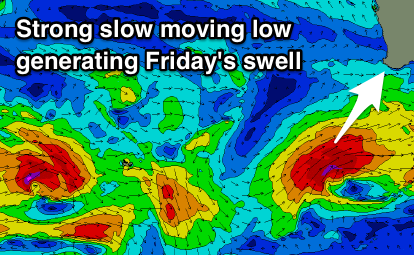 Our SW groundswell for the end of the week has been upgraded, with the polar low generating it, moving slower and remaining at strength for a longer period in our swell window.
We should see a fetch of severe-gale W/SW winds projected slowly through our swell window today and tomorrow before the system continues further east under the country.
A good long-period SW groundswell will result, filling in rapidly Friday and peaking through the day to 8ft to possibly 10ft across the South West, 3ft in Mandurah and 2ft+ in Perth.
Winds look great as the low pushes east resulting in E/SE offshores across Mandurah and Perth, while Margs looks to see S/SE-SE winds, favouring protected spots.
The swell will ease off fairly rapidly through Saturday from 6ft+ across the South West, 2ft+ in Mandurah and 1-2ft in Perth but with early E/NE offshore winds. Conditions will deteriorate through the day as winds tend N/NE.
Sunday will see winds hold out of the NE as the swell continues to drop favouring magnets across the South West.
Moving into next week a mix of background SW groundswell and mid-period W/SW swell are due to build Monday and more so Tuesday with varying SE tending S/SW winds as a surface trough slowly moves in from the west.
A slightly stronger long-period SW groundswell may be seen late week, but we'll have another look at this on Friday.
Comments
G'day Grubb I need a rhino chaser Red.