Improving surf late week, fun for a window over the weekend

Western Australia Surf Forecast by Craig Brokensha (issued Wednesday 8th August)
Best Days: Perth and Mandurah Friday morning, all locations Sunday morning
Recap
Poor onshore and weak surf through yesterday, stronger this morning with some new groundswell in the mix but with a continuation of poor conditions. There was a slim window of cleaner conditions around Perth, but conditions were still lumpy and not ideal.
Today’s Forecaster Notes are brought to you by Rip Curl
This week and weekend (Aug 9 – 12)
Want to receive an email when these Forecaster Notes are updated? Then log in here and update your preferences.
Today's swell is on the ease and we'll see it replaced by a sizey NW windswell tomorrow as a strong mid-latitude front pushes into us, bringing strong NW winds overnight.
The windswell will be larger than the leftover groundswell early tomorrow morning but very poor in quality with onshore W/SW and then SW winds.
Some new W/SW groundswell will fill in rapidly through the day, linked to the earlier stages of the mid-latitude storm in the Southern Indian Ocean over the last couple of days. Sets should reach 8ft through the day across the South West, while Perth and Mandurah look a stormy 3ft out of the NW, with the W/SW swell to 2-3ft.
 The swell will ease through Friday and our window of S/SE winds around Perth and Mandurah is still on the cards, dropping from 2-3ft, while Margs will remain onshore with winds out of the S/SW.
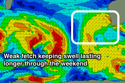
Saturday morning is still looking clean across the South West with a morning E/NE offshore, but and we've got a touch more size due to linger on the coast owing to a weak fetch of W/SW winds pushing towards us this evening and tomorrow.
It'll be mid-period W/SW energy but fun and easing from 4-6ft, 2ft+ in Mandurah and 2ft in Perth.
Come Sunday winds will quickly freshen from the N/NE and then tend N/NW, but with no new swell, it will be very marginal.
Next week onwards (Aug 13 onwards)
Moving into next week we're due to see another flurry of strong mid-latitude frontal activity impacting the state, but the onshore winds won't last anywhere near as long, but in saying this they look to impact the peak of the swell and the following day.
More on this Friday though.