Windy XL surf on the weekend, best in protected spots

Western Australia Surf Forecast by Craig Brokensha (issued Friday 3rd August)
Best Days: Protected spots tomorrow and Sunday morning, keen surfers early Monday across Perth and Mandurah,
Recap
Large easing stormy surf across the South West yesterday with strong onshore winds, lighter and more variable for a short period around Perth and Mandurah creating cleaner though still raw and bumpy conditions.
This morning we've got stormy onshore conditions across all locations again with a mix of windswell and groundswell.
Today’s Forecaster Notes are brought to you by Rip Curl
This week and weekend (Aug 4 - 10)
Want to receive an email when these Forecaster Notes are updated? Then log in here and update your preferences.
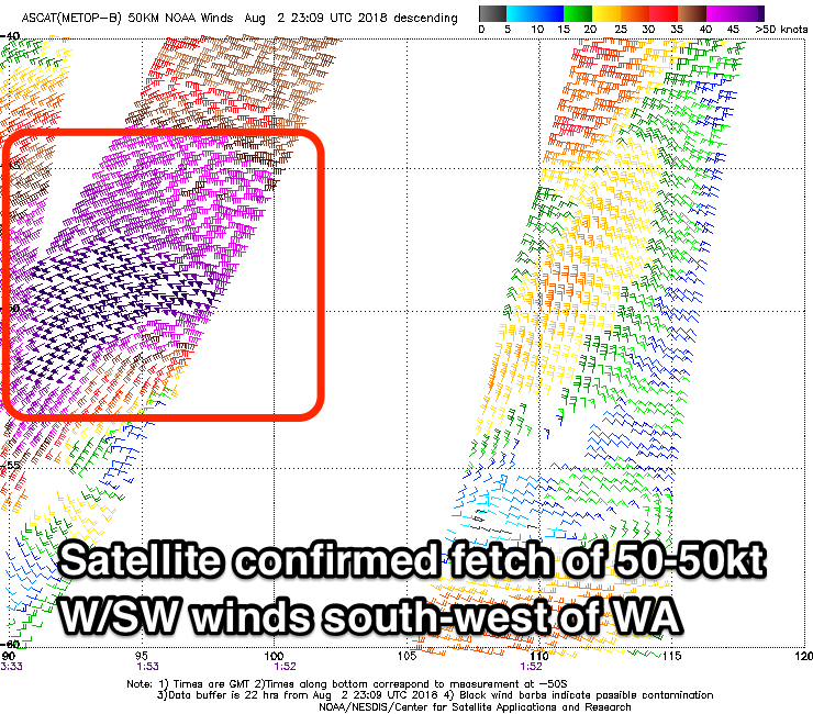 Today's continuation of strong onshore winds and building stormy swell is linked to a severe-low that's currently to our south-west, projecting a fetch of storm-force W/SW winds through our south-western swell window.
This low developed yesterday and satellite observations confirmed winds reaching 50-55kt at its peak intensity.
We'll see an XL SW groundswell pushing in tomorrow off this low, peaking during the middle of the day/afternoon across the South West with 12-15ft surf due on the exposed reefs, much larger at deep water reefs.
Mandurah and Perth should build to 4-5ft and 3ft+ respectively into the afternoon but conditions will be poor across all locations and best in protected spots with a fresh to strong SW tending S/SW breeze.
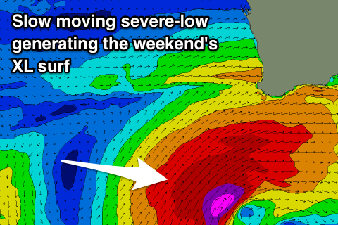 The low will actually stall off our south coast through tomorrow while weakening slowly, but we'll continue to see a fetch of severe-gale to storm-force S/SW winds generated in our southern swell window this evening, weakening slowly through tomorrow.
This will soften the easing trend through Sunday with oversized sets to 10-12ft across the South West, easing slowly through the day and then more noticeably from 5-6ft Monday.
Perth looks to ease from 3ft Sunday morning with 3-4ft sets in Mandurah and looking at the local winds, gusty S/SW winds will dominate most coasts, with a period of S/SE breezes around these regions about 50/50 now owing to the stalling nature of the low.
Monday looks more likely with an early E/NE breeze across Mandurah and Perth but the swell will be much smaller, 2ft on the former and 1-2ft later.
The South West will be poor with a mid-latitude front bringing strengthening W/NW winds, developing to the north through the morning.
No major swell is due off this mid-latitude front with it strengthening late in our swell window resulting in mid-period windswelly waves along with persistent W'ly tending W/NW winds.
A better storm strengthening west-southwest of us early next week is forecast to generate a fetch of severe-gale to near storm-force winds, producing a new large SW groundswell for Thursday. This again looks to be met with onshore W'ly winds as another mid-latitude front quickly races in and across us Wednesday evening.
There may be some respite on the backside of the swell Friday and Saturday morning, but longer term we've got more large to extra-large surf on the cards for the middle of the month.
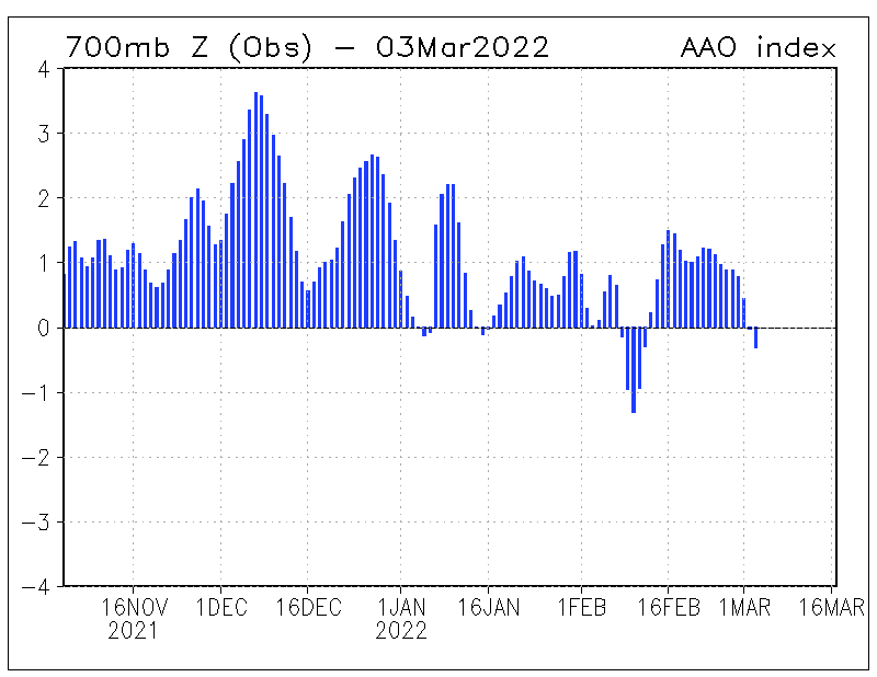
This persistent mid-latitude frontal activity is due to a strong negative Southern Annular Mode signal (SAM). When the SAM is negative we see the polar westerlies shift more northward, and vice versa when positive, high pressure dominates with clearer more stable weather.
We'll have another look at all this Monday though. Have a great weekend!
Comments
damn you southern annular mode (SAM) signal! I knew it!