Large to extra-large surf to continue

Western Australia Surf Forecast by Craig Brokensha (issued Wednesday 1st August)
Best Days: Protected spots Saturday, Mandurah and Perth Sunday morning
Recap
Pumping surf across Perth and Mandurah yesterday morning with clean conditions and solid 3-4ft sets, while Margs also saw an early window of OK winds, though conditions remained raw and bumpy.
This morning we've got a building stormy NW tending W/SW swell as a vigorous mid-latitude front projects into us with very poor conditions.
Today’s Forecaster Notes are brought to you by Rip Curl
This week and weekend (Aug 2 - 5)
Want to receive an email when these Forecaster Notes are updated? Then log in here and update your preferences.
Currently a very strong and far northward propagating frontal system is pushing across us, with a fetch of strong to gale-force W/SW tending SW winds coming with it.
This will see produce a large stormy increase in W/SW swell through this afternoon and evening, holding into early tomorrow morning before easing slowly through the day as stronger levels of large W/SW groundswell fill in.
Size wise Perth looks to come in at 4ft, 4-6ft across Mandurah and 10-12ft across the South West along with fresh to strong SW tending W/SW winds. This won't leave many options at all, with super protected spots the go to for experienced surfers.
 Friday looks to become a touch smaller but with strong W'ly tending W/NW winds, kicking up a fresh increase in poor windswell through the day.
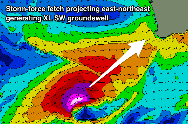
Our new SW groundswell for the weekend has been upgraded, with a severe-low now forecast to develop south-west of us and this evening, with a pre-frontal fetch of severe-gale W/NW winds setting in motion an active sea state for a stronger storm-force fetch of W/SW winds to slowly move over, projecting east-northeast towards the Bight and through our south-western swell window.
We're now looking at XL long-period surf filling in Saturday, coming in at 12-15ft across the South West, peaking through the middle of the day/afternoon, with Mandurah building to 4-5ft, and a strong 3ft in Perth into the afternoon.
Winds are still an issue and protected spots will be best with a strong SW tending S/SW breeze, holding into Sunday and remaining moderate to fresh across the South West as the swell eases.
Mandurah and Perth are likely to see a period of more favourable S/SE winds Sunday morning with easing sets from 3-4ft and 3ft respectively.
Moving into early next week we'll see the swell settle down temporarily as the mid-latitude fronts lose steam, but we'll continue see them slipping across us, bringing strengthening W/NW winds on Monday, tending W/SW on Tuesday with an average increase in moderate sized windswell.
Of greater importance is another severe-low that's forecast to develop west-southwest of us early next week, deepening and projecting a fetch of slow moving severe-gale to storm-force W/SW winds towards and then into us late week.
This will see another stormy XL W/SW swell developing with onshore winds, but more on this Friday.