Large windy surf to continue

Western Australia Surf Forecast by Craig Brokensha (issued Monday 30th July)
Best Days: Early tomorrow Perth and Mandurah, Saturday protected spots, early Sunday Perth and Mandurah
Recap
Our XXL long-period W/SW groundswell filled in strongly on Saturday producing very large and overpowering surf across the South West, solid 4-5ft+ waves across Mandurah and easy 4ft sets across Perth.
Conditions were great across Perth and Mandurah and OK around the South West with variable tending light offshore winds, N'th into the afternoon.
Sunday was poor across the South West and Mandurah with a drop in swell and fresh to strong W/NW winds, while Perth early workable N'ly breezes before shifting W/NW.
This morning we hit a low point in swell, but a new swell has already started to kick in, with OK winds and conditions around Perth and Mandurah with 2-3ft of swell, bigger across the South West and best in protected spots as expected on Friday.
We should see the new swell reaching 8ft to occasionally 10ft across the South West this afternoon, with consistent 3ft waves in Mandurah and Perth but with onshore winds.
Today’s Forecaster Notes are brought to you by Rip Curl
This week and weekend (Jul 31 – Aug 5)
Want to receive an email when these Forecaster Notes are updated? Then log in here and update your preferences.
Today's W/SW swell was generated by a strong mid-latitude frontal system that developed south-east of South Africa and moved east through the weekend, with a slight intensification to our south-west yesterday due to produce a reinforcing SW pulse for tomorrow morning.
Margs should still see large 8ft+ sets on the exposed reefs, easing into the afternoon, with easing 3ft waves in Mandurah and 2-3ft Perth with early E/NE winds north of Margs and onshore from the N/NW across the capes. There's a very very slim chance for a dawn N/NE breeze around Margs, but surfing options will be near nil.
This strengthening NW'ly will be associated with a broad and vigorous storm that's currently north of the Heard Island projecting up and across us under the influence of a strengthening and eastward moving node of the Long Wave Trough.
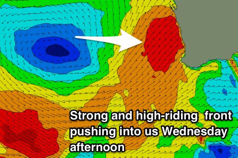 We're already seeing a broad fetch of strong to gale-force W/SW winds in our western swell window, with this fetch slowly projecting east-northeast towards us while strengthening and then pushing across us through Wednesday.
What we'll see is an increase in poor NW windswell Wednesday morning ahead of an increase in stormy W/SW windswell and then groundswell filling in on Thursday and peaking through the afternoon.
Strong W/NW winds are due to swing more W/SW and then gale-force SW through Wednesday, abating slowly from the strong to gale-force range on Thursday.
Size wise, the storm-swell and groundswell look to come in at a similar size on Thursday with easing 4ft surf across Perth, 4-6ft in Mandurah and 10-12ft waves across the South West.
Another storm developing to our south-west will project a pre-frontal fetch of W/NW gales up into us, with stronger post-frontal gale to severe-gale W/SW winds, generating a building windswell through Friday followed by better groundswell on Saturday.
Strong S/SW winds look to create poor conditions as the SW swell fills in, with Margs due to build to 12ft+, 3-5ft in Perth and 3ft in Mandurah.
On the backside of the swell there doesn't seem to be a window of cleaner conditions across the South West but Perth and Mandurah may see early light variable winds.
Moving into next week it looks like the frontal activity will die down, but poor winds will remain as weaker fronts continue to remain north in latitude. More on this Wednesday though.
Comments
It,s good to see nice barrelling waves on the beachies. Wish I was there.
Yeah, pumping!
Hi Craig,
Hope you're well! Just confused by these seemingly contradictory statements:
"... then groundswell filling in on Thursday and peaking through the afternoon."
"...look to come in at a similar size on Thursday with easing 4ft surf across..."
is the swell filling in or easing?
And if this backwards...?
"....3-5ft in Perth and 3ft in Mandurah."
Cheers for the input