Best window across the South West Saturday morning

Western Australia Surf Forecast by Craig Brokensha (issued Wednesday 13th June)
Best Days: Perth and Mandurah Thursday morning, South West Friday afternoon, all locations early Saturday morning, Perth and Mandurah early Sunday and Wednesday morning
Recap
Average conditions across all locations yesterday with a further drop in swell, while today a mix of new mid-period W/SW swell and stronger SW groundswell have filled in through the day across all locations.
Margs has been onshore but has kicked to 6-8ft, while Perth and Mandurah saw our expected light winds and good clean 2-3ft surf.
Today’s Forecaster Notes are brought to you by Rip Curl
This week and weekend (Jun 14 - 17)
Want to receive an email when these Forecaster Notes are updated? Then log in here and update your preferences.
Unfortunately our lingering onshore wind for tomorrow across the South West is still on the cards with a moderate W/SW breeze as today's SW groundswell eases.
Perth and Mandurah will be clean again with variable tending light E'ly winds and easing 2-3ft sets.
 A more variable breeze from the NE is due Friday morning across the South West but the swell will be smaller and back to the 4ft range with 1-2ft waves in Perth and Mandurah.
Winds should remain fairly light all day from the northern quadrant as a new long-period SW groundswell fills in. This swell was generated by a strong but relatively short-lived polar low and will likely boost the exposed reefs back to 4-6ft later in the day with 1-2ft waves in Mandurah, becoming tiny in Perth.
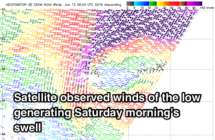
A stronger long-period SW groundswell is due Saturday morning though, generated by a vigorous low that's currently west-southwest of us, generating a fetch of severe-gale to storm-force W/SW winds while tracking east-southeast.
This low is a little stronger than forecast on Monday and we've got a slight upgrade in the expected size, with strong 6-8ft sets expected across the South West. Looking at the ASCAT satellite readings, there could be the odd bigger cleanup in the mix, but the east-southeast track will likely keep a cap on this.
Mandurah should offer strong 3ft sets, with 2ft to maybe 3ft waves in Perth, easing through the day.
Winds will be good through the early morning and out of the E/NE, but a shift to the N/NE is due through the day, so get in before lunch.
Yet another and more westerly pulse of long-period W/SW groundswell is due on Sunday, produced by a secondary broader and more expansive storm firing up behind the tight low, with a slim pre-frontal fetch of severe-gale W/NW winds due to be followed by post-frontal W/SW gales.
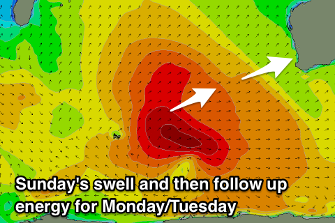 We should see the swell kick back to Saturday morning's size on Sunday, but winds will deteriorate with a strengthening N/NE tending N/NW breeze as a secondary intensification of the storm pushes east and encroaches on us.
This secondary intensification will generate a large reinforcing pulse of W/SW swell for Tuesday up in the 8ft range across the South West, 3ft Mandurah and 2-3ft Perth, mixed in with windswell as the progression moves across us.
This will all go to waste though with strong W/SW winds Monday and W/SW tending S/SW winds Tuesday.
Wednesday morning Perth and Manudrah are likely to see E'ly offshores with the W/SW groundswell easing, onshore from the S/SW across the South West. More on this Friday though.