Fun swells from Sunday with workable winds

Western Australia Surf Forecast by Craig Brokensha (issued Friday 19th January)
Best Days: Saturday morning magnets in the South West, Sunday protected spots in the South West, every morning from Monday onwards
Recap
A small spike in swell across Perth and Mandurah out of the NW with 2ft sets and light winds early ahead of a change. Margs was cross-shore and fairly average.
Today offshore winds have kicked back in with tiny clean waves in Perth and Mandurah but fun sized sets at swell magnets across the South West. We should see sets hitting 3-4ft this afternoon with a new SW swell.
Today’s Forecaster Notes are brought to you by Rip Curl
This weekend and next week (Jan 20 - 26)
This afternoon's small increase in SW groundswell across the South West should ease back through tomorrow, from 3ft+ across magnets (tiny to the north) with an offshore E/SE breeze ahead of sea breezes.
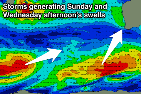
Our stronger S/SW groundswell for Sunday is still on track, with a slight upgrade in the expected size owing to the polar frontal progression generating it being a touch stronger. We've seen a good elongated fetch of W/SW gales east of Heard Island generating this swell, with a late increase likely Saturday ahead of a peak Sunday to 4-6ft across South West magnets, 1-1.5ft in Mandurah and 1ft in Perth.
Winds still look average though with a gusty S/SE breeze persisting all day in the South West, with stiff W/SW sea breezes further north.
 A fresh SE'ly will create cleaner conditions Monday morning as the swell drops back temporarily to 3-5ft.
We should see a new swell starting to build through the afternoon but more so Tuesday/Wednesday generated by a secondary elongated and good fetch polar W/SW gales, weakening while racing ahead of itself and moving south of us Sunday.
We'll see some good mid-period SW swell building Tuesday ahead of less consistent longer-period energy on Wednesday.
Size wise Margs should build later Monday further Tuesday to a peak around 4-5ft into the afternoon, 1-1.5ft in Mandurah and 1ft Perth.
Wednesday will see similar sized sets but into the afternoon the less consistent longer-period energy should fill in providing stronger 6ft sets across the South West but no real additional size to the north.
Winds should be SE each morning before strengthening from the S/SE into the afternoons.
We'll see the swell slowly ease into the end of the week with SE winds again each morning.
Longer term we're looking at a relatively weak polar front projecting up and towards us late week, generating a new mid-period swell for next weekend, but more on this Monday. Have a great weekend!