Buckle up for the onshores

Western Australia Surf Forecast by Craig Brokensha (issued Friday 21st July)
Best Days: Tuesday morning Mandurah and Perth
Recap
XL stormy waves out across the South West yesterday, with solid messy 3-5ft waves in Mandurah and 3-4ft junk around Perth. There were no real quality options for a surf though with the strong onshore winds.
Today the surf was half the size as poor onshore winds continued.
This weekend and next week (Jul 22 – 28)
Buckle up, we're in for a prolonged period of onshore winds and large swells, especially into later next week.
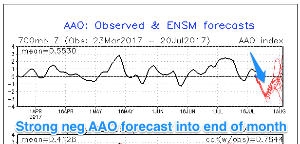 We've got a double whammy, with a broad, strengthening and stalling node of the Long Wave Trough through next week as well as a strong negative SAM/AAO event.
The Southern Annular Mode (SAM/AAO) is an index showing how far north or south the polar westerlies (storm track) is from normal. When it goes positive the westerlies shift further south and away from us, but when negative they shift closer.
The forecast is for the SAM to take a strong negative dive into the end of the month, couple this with a strengthening and stalling node of the Long Wave Trough in our region and we're set to get slammed by non-stop frontal systems and with strength.
Coming back to the weekend and a strong front pushing into us today should generate a mid-period W/SW swell for tomorrow, coming in at 6-8ft across the South West and 2-3ft in Perth, easing back into the afternoon and Sunday.
Unfortunately fresh W'ly winds will spoil the swell tomorrow, while a weak front passing across us Sunday will bring stronger W/NW tending W/SW winds.
Winds may back off slightly around Perth and Mandurah Monday morning but the swell will be an inconsistent 2ft on the sets. Fresh W'ly winds will continue in the South West.
 The first of a series of inconsistent long-range W/SW groundswells from under South Africa and the south-west Indian Ocean are due into Monday.
This first swell is expected to build Monday, with a reinforcing pulse Tuesday to the 6ft+ range across the South West and 2ft+ in Perth and Mandurah.
Winds should take a NE bias Tuesday morning to the north of Margs, creating clean conditions, while N/NW breezes will continue to create average conditions otherwise.
A very long-period W/SW groundswell is due into Wednesday, produced by the strongest of the storms firing up under South Africa and pushing east towards us today and tomorrow. The storm will break down west of Heard Island, resulting in a fair bit of swell decay, but before this a fetch of storm-force W/SW winds will be generated.
There'll be very long waits between sets but the long-period forerunners are due Tuesday afternoon to 22s, with the bulk of the swell due Wednesday afternoon with sets to 10ft to possibly 12ft in the South West and 2-3ft in Perth and Mandurah. This swell will be hard to discern under strengthening NW tending W/NW winds unfortunately.
Into the end of the week is when we'll start to really feel the effects of the strengthening Long Wave Trough over us, with vigorous mid-latitude storms firing up and slamming into us, generating large-extralarge stormy surf. More on this Monday though. Have a great weekend!
Comments
And everyone thought it was going to be a mild winter
Funny how BOM forecast a dryer ,milder winter with less intense fronts.
I reckon they might look out the window and change their mind !
Craig this is brilliant great scribe cheers
So that explains why the fronts have continued of late ?
More rain with in the fronts i guess .
The clam will cling on tight for the time being
Just don't read the NSW reports! It won't make you feel any better:(
Cheers Clam, very interesting and dynamic pattern for WA, just a waste of swell though. Indo however.
Craig what happened to the dry winter is it done with for a while in sa& vic too ?
It's not my area of expertise but looking at the coming two weeks there's finally moisture coming across.