Fun weekend across exposed breaks, poor next week

Victorian Surf Forecast by Craig Brokensha (issued Friday March 29th)
Best Days: Tomorrow morning, Sunday morning to the east, Friday morning to the east
Features of the Forecast (tl;dr)
- Inconsistent SW swell later in the day today, easing tomorow AM
- Better, SW groundswell building tomorrow PM, easing Sun
- Variable winds tomorrow AM, with SE sea breezes arriving later AM
- Light E-E/NE winds Sun AM ahead of sea breezes
- Small to tiny Mon with N/NE winds, freshening (tending N/NW for a period to the west)
- Small to tiny Tue with strong W/NW tending SW winds
- Small-moderate sized, mid-period SW swell for Wed along with some moderate sized S/SW windswell. Strong S/SW winds
- Moderate sized mid-period SW swell for Thu PM, holding Fri
- Fresh S winds Thu, E/NE-NE Fri AM ahead of sea breezes
Recap
Poor surf yesterday with moderate to fresh onshore winds and easing surf back to 2-3ft yesterday, holding 2ft this morning on the Surf Coast with cleaner conditions for the beaches, 3-4ft to the east.
This weekend and next week (Mar 30 – Apr 5)
Looking at the weekend ahead and we've got a couple of swells due, with tomorrow morning expected to offer the cleanest conditions for the Surf Coast, with the beaches being cleanest on Sunday morning.
Firstly, an inconsistent mid-period SW swell is due this afternoon and tomorrow morning, generated by a healthy fetch of W/NW winds to the east of the Heard Island region at the start of the week.
Inconsistent 2ft to occasionally 3ft sets are likely on the Surf Coast magnets, 4ft+ to the east and with early variable winds that should tend locally light offshore, giving into SE sea breezes from later morning.

Through the afternoon tomorrow, a flukey pulse of SW groundswell from a healthy fetch of NW gales tracking south-east towards the polar shelf is due. We should see radial spread and great circle paths do their work regarding size for the Victorian coast, with a more pronounced 2-3ft of swell likely on the Surf Coast into the afternoon, 4-5ft to the east.
The swell will peak overnight and then ease back from 2ft to possibly 3ft at dawn Sunday on the Surf Coast, 4ft to the east and with light E-E/NE winds ahead of sea breezes.
Monday looks smaller as the swell fades with favourable N/NE winds to the east of Melbourne, shifting N/NW on the Surf Coast for a period before freshening from the N/NE into the afternoon.
We then look at the strengthening polar frontal activity due to the south-southwest of Western Australia and under the country from Sunday through next week.
Initially, a couple of weak fronts will generate fetches of strong W/SW-W/NW winds and a small, mid-period SW swell for Wednesday, coming in at 2-3ft on the Surf Coast and 4-5ft to the east.
We should see the frontal activity increase a little in scope and intensity during next week, generating more size for Thursday afternoon and Friday that looks come come in more around the 4ft range on the Surf Coast, 5-6ft to the east.
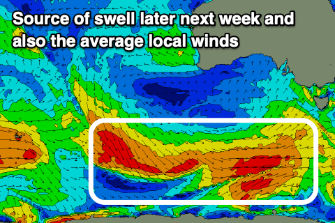
The only issue through this period are the local winds, with a deepening trough due to form into a low as it moves across us Tuesday, bringing strong W/NW tending SW winds on that day, remaining strong from the S/SW Wednesday.
This will kick up some larger, localised windswell, with winds due to persist from the S'th on Thursday thanks to a ridge of high pressure moving in from the west, remaining fresh before easing into the evening.
Friday may see winds shift E/NE-NE with the peak in SW swell energy, but we'll have to review this Monday.
Into next weekend, N'ly winds are likely with moderate amounts of back-up mid-period SW swell, though check back Monday for the latest. Have a great weekend!
Comments
hmmmmm
Indeed.
Who’s the best groveller left in the draw?
They’ll live to regret not smashing through the heats last Monday.
Why?
WSL's permit doesn't allow competition to be held on the Monday. There are literally zero circumstances in which they could have run that day.
I think he meant Tuesday. Overlapping heats etc.
I don't think overlapping heats would have been justified on Day 1.. they ended up doing 11 hours which was a mammoth day in anyone's books.
I thought they would run overlapping heat Wed at Winki.
Probs just enough waves to do so, considering the f/cast.
So how do you see bells going?
Finish when?
Finishing next Friday but it's going to be a long, drawn out tricky event.
Fun on the eastern beaches this morning despite the crazy low tide. Just small for the banks to handle it.
The tour needs to be mobile but won’t happen so shitsville it will stay unless they jag at stops
this has been the best event to watch all year. so far.
Johanna might have been good today .
They used 2 B able 2 move the Comp over there , 2 find swell .
yea it was good fun there this morning + a few pros getting amongst it too.