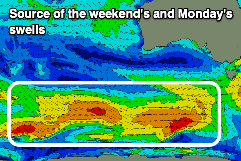
Tricky winds for the coming days with plenty of swell better from Sunday

Victorian Surf Forecast by Craig Brokensha (issued Monday March 18th)
Best Days: Tomorrow ahead of the change, Friday morning Surf Coast for the keen, Sunday morning Surf Coast, Monday morning, Tuesday
Features of the Forecast (tl;dr)
- Moderate sized, inconsistent W/SW groundswell building tomorrow PM with strengthening N/NE winds, tending W/NW early PM ahead of a strong SW change
- Easing swell Wed with strong SW winds (low chance of early W winds Surf Coast)
- Moderate sized, mid-period SW swell Thu with light-mod S/SE winds
- Smaller Fri with light S/SW winds, increasing (likely W/NW early Surf Coast)
- Moderate sized, mid-period SW swell building Sat, peaking Sun with freshening S'ly winds Sat, variable Sun AM
- Moderate sized SW swell persisting Mon with variable offshore winds ahead of sea breezes
- Moderate + sized SW groundswell Tue with variable N winds ahead of sea breezes
Recap
The exposed beaches offered the best waves and conditions over the weekend with a clean, easing 3-4ft of swell Saturday, smaller and to 2-3ft yesterday. A flukey pulse of small, mid-period S/SW swell due into afternoon didn't really offer much size until later, with it easing today from 2ft and 2-3ft west and east of Melbourne respectively.

Fun leftovers today
This week and weekend (Mar 19 -24)
The coming period is tricky thanks to generally troughy weather and flukey winds. There'll be swell but finding a good, clean wave will be tricky until next week.
Tomorrow will be a race against the incoming change and a building W/SW groundswell across the state, with the groundswell generated by a strong low moving through our medium-range swell window later last week and into the weekend.
A good fetch of pre-frontal gale to severe-gale W/NW winds were generated, with a moderate sized pulse of W/SW groundswell due to arrive through afternoon, building towards a peak through the evening. It looks like we've got a slight downgrade in size, but it'll be onshore at the peak regardless.
Ahead of the swell, the surf looks generally small but clean with a strengthening N/NE breeze that will shift W/NW into the early afternoon and then strong SW mid-late afternoon.
With this the exposed beaches look best though windy before lunch, with a window on the Surf Coast into the afternoon, but the swell will likely still be slow.
The Surf Coast should reach 3-4ft late with 5-6ft sets to the east, easing from 3ft and 4-5ft Wednesday morning but with winds remaining strong from the SW. There's an outside chance of lighter W'ly winds around Torquay but it won't be pretty and the frontal system will bring with it lots of low quality windswell.
Weak, mid-period SW swell should persist Thursday to a similar size as Wednesday and winds will weaken but linger out of the S/SE, creating bumpy conditions with nothing of real quality about.
Friday will become smaller and winds again look to linger out of the S/SW, freshening through the day. A light W/NW'ly is more than likely on the Surf Coast but with weakish 2-3ft sets.
As we move into the weekend, some new mid-period SW swell should fill in, with it being moderate in size, generated by a healthy progression of frontal systems under the country over the coming days. Various fetches of strong W'ly winds will perk up the size on Saturday, reaching 3-4ft on the Surf Coast and 5-6ft to the east, holding a similar size on Sunday.

Unfortunately freshening S'ly winds will create poor conditions Saturday, possibly going more variable into Sunday but with a SW tendency, so the Surf Coast will fair best under early W/NW winds.
Looking at next week, and there's some stronger swell on the cards for the state under favourable winds as the westerly storm track remains active and a high pushes in from the west. This should see winds tend variable and locally offshore on Monday, similar Tuesday but likely more N'ly in direction.
Size wise, Monday should be similar to Sunday, but a larger SW groundswell is on the cards for Tuesday, coming in the 4-5ft range on the Surf Coast and 6-8ft to the east, but we'll review this on Wednesday.
Comments
I'm at work but can someone please screenshot or at least double check i'm not seeing things: Boings cam, 13th someones parked a tesla at the stairs?
That they have, now gone..
Toorak boardriders club