Fun end to the week, dynamic into next week

Victorian Surf Forecast by Craig Brokensha (issued Wednesday 8th November)
Best Days: Today ahead of the change, tomorrow morning, Friday ahead of sea breezes, Sunday morning Surf Coast, Tuesday and Wednesday mornings Surf Coast
Features of the Forecast (tl;dr)
- Small-mod sized mid-period SW swell building today with increasing S/SW winds across all locations from midday onwards
- Swell easing slowly tomorrow with variable tending S/SE winds
- Smaller, easing surf Fri with NE winds ahead of mid-late afternoon sea breezes
- Low point in swell Sat with strengthening SW winds (variable early)
- Moderate sized W/SW swell Sun with W/NW tending strong SW winds
- Slight drop in swell Mon AM ahead of a new moderate sized S/SW swell for the PM, peaking Tue AM
- Light-mod SW winds Mon, increasing (possibly light W early Surf Coast)
- Light S/SW winds Tue, freshening from the S/SE into the PM
- Large S/SW groundswell building Tue PM, peaking Wed with moderate S/SW-S winds, strong S/SW into the PM
- Large choppy surf Thu with strong SW winds, easing Fri with S/SW winds
Recap
Following a great day of waves on the beaches Monday, early yesterday dawned a little funky to the east as thunderstorms pushing through to the south drew in south-southeast winds behind them, adding bumps to the slightly smaller 3ft+ of swell. Conditions quickly righted themselves and improved through the morning thanks to developing offshore winds which remained favourable until late afternoon. The Surf Coast was clean and peaky with 2ft sets across the beaches for the keen.
This morning the swell is a touch smaller and slower but clean to the east again with 3ft+ surf, foggy to the west with a variable onshore wind and 2ft of swell as a trough starts moving in from the west. A new pulse of swell looks to be now showing with sets to 4ft on the exposed beaches.
The fog has also now enveloped the east, ahead of the trough - which will bring a freshening S/SW change to the west by midday, reaching the east mid-afternoon or so.

Sea fog creeping in
This week and next (Nov 9 – 17)
This afternoon's S/SW change will spoil a new pulse of mid-period SW swell that's due to bump wave heights back up from the slow easing trend seen the last day or so.
It's source was distant so it'll be inconsistent but 2-3ft sets are on the Surf Coast magnets, 4ft+ to the east, holding a similar size tomorrow morning before easing.
Winds look to go variable following today's change, light W/NW to the west and variable SE-S/SE to the east which will provide fun options before sea breezes kick in.
Friday looks great for the exposed beaches with a light NE offshore, holding until mid-afternoon before E/SE sea breezes kick in, SE across Phillip Island.
So all in all the fun run for the exposed beaches looks to continue this week.
Moving into the weekend we'll see a stronger and more pronounced S/SW change arrive Saturday morning as the swell reaches a low point. This will be a lay day but another approaching front on Sunday should tip winds back to the W/NW for a short period along with a fun pulse of W/SW swell.
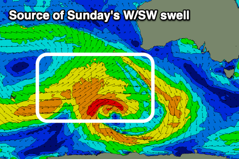
The source of this swell is a broad, slow moving polar low that formed around the Heard Island region on Monday, with it currently generating fetches of strong W/SW winds through our western swell window, to the south-west of Western Australia.
The low will weaken while moving further east over the coming days, though a stronger polar frontal progression is due to develop on its tail, south-west of us on the weekend, discussed in more detail below.
Sunday's swell should come in at 3ft on the Surf Coast and 5-6ft to the east, with those morning W/NW winds that will then quickly revert back to the SW and strengthen.
Monday morning looks a touch smaller and with lingering but weaker SW winds across most locations, though the Surf Coast will likely see early light W'ly breezes.
Now, coming back to the stronger polar frontal progression developing south-west of us on the weekend, and an initial low will generate a fetch of strong to near gale-force W/SW winds through our southern swell window, followed by a secondary front that will generate an elongated fetch of W/SW gales.

This will produce larger and stronger levels of swell, with the first arriving later Monday but peaking Tuesday to 4ft+ on the Surf Coast and 6ft+ to the east, with a larger groundswell for later in the day and more so Wednesday to 5-6ft and 6-8ft respectively.
Winds are a little dicey with light S/SW breezes Tuesday morning freshening from the S/SE through the day, back to moderate S/SW-S on Wednesday, strong into the afternoon. While not ideal the mornings should offer OK conditions for a surf both days.
The end of the week is a little uncertain but strong SW winds look likely Thursday and then S/SW on Friday but we'll have a closer look at this on Friday.