Fun weekend, slow ahead of a strong swell later next week

Victorian Surf Forecast by Craig Brokensha (issued Friday 26th June)
Best Days: Saturday and Sunday, desperate surfers Monday morning, late next week
Recap
Clean conditions though tiny and easing surf across the Surf Coast yesterday, bumpy and workable for the desperate on the Mornington Peninsula through the morning.
Today a small new mix of weak W/SW swell and long-period, long-range energy has provided clean and small 1-2ft waves in protected spots on the Surf Coast, bumpy and poor to the east. We should see a better mid-period W/SW swell building later today to 2-3ft on the Surf Coast and 4-5ft to the east as winds shift onshore to the SW but without much strength.
This weekend and next week (June 27 – Jul 3)
There’s been no change to the peak in mid-period W/SW swell due tomorrow morning across the state. The broad and slow moving mid-latitude low linked to it, and the consequent weak front that pushed into us yesterday have now exited our swell and we’ll see fun waves in the 3ft range across the Surf Coast tomorrow morning, 4-5ft+ to the east.
A slight drop in size is expected through the afternoon, down further from 2ft+ on the Surf Coast swell magnets Sunday morning, 3-4ft to the east.
Winds look mostly favourable for a wide selection of breaks and light from the N/NW tomorrow morning, tending variable into the afternoon and possibly N/NE-NE later. Sunday looks similar with N/NW breezes on the Surf Coast, varying between N/NE-N/NW to the east and then N/NE into the afternoon.
Moving into next week, the beaches will remain clean with a N/NE breeze Monday morning but the swell will be tiny on the Surf Coast, slow to the east and 2ft to possibly 3ft with a background groundswell.
As touched on the last few updates, there’s no new swell due until late in the week as a strong node of the Long Wave Trough sitting over WA pushes slowly east, bringing a flurry of significant mid-latitude frontal activity more into our swell window.
Ahead of this frontal activity winds will strengthen from the N/NE on Tuesday and persist Wednesday but with no new note-worthy swell, more N/NW on Thursday.
Come Friday we’ll see our first increase in W/SW groundswell from this progression, with a very strong low due to develop east of the Heard Island region and project east-northeast through our western swell window.
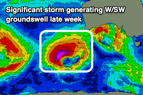 A significant fetch of severe-gale to storm-force W/SW winds will be generated before the storm projects further into the Bight. From here the models diverge with EC showing the progression continuing into us but with less strength while GFS pushes it north and inland.
Either way we’re due to see a moderate to large, long-period W/SW groundswell, arriving later Thursday but peaking Friday. At this stage it looks like we’ll see surf to 4-5ft on the Surf Coast swell magnets, 8ft on the sets to the east and with NW winds ahead of a SW change. We’ll have to take a closer look at the size, timing and local winds for this swell event in next week’s updates. Have a great weekend!
Comments
That 19s 2ft swell is lingering. Small waves that would close outs banks ha