Building westerly swells, initially average

Victoria Forecast by Craig Brokensha (issued Monday 15th October)
Best Days: Exposed beaches for keen surfers later tomorrow, Wednesday morning keen surfers, Thursday both coasts (early MP), Friday exposed beaches
Recap
Good clean conditions but only small across all coasts on Saturday with the exposed beaches the go, small to tiny Sunday with just the odd random set across the Mornington Peninsula beaches for bigger boards.
This morning the swell has bottomed out with tiny to flat conditions across most breaks, say for the odd small 1-2ft set on the beaches to the east.
Today’s Forecaster Notes are brought to you by Rip Curl
This week and weekend (Oct 16 - 21)
Tomorrow morning will remain tiny to flat and a persistent NE offshore will favour the exposed beaches across the state all day.
Into the mid-late afternoon our new small W/SW groundswell is due to fill in, generated by a distant polar low over near the Heard Island region late last week.
The Surf Coast isn't expected to see much in the size department with only a small 1-2ft set likely late in the day, while the Mornington Peninsula may see 2-3ft sets.
The swell is due to peak Wednesday to a slightly better 2ft and 3ft+ respectively, though very inconsistent.
 Winds will be favourable for both locations with light local offshore breezes, before a surface trough brings a weak SE change into the afternoon.
Our better groundswell for Thursday is still on track and winds are looking much better as well.
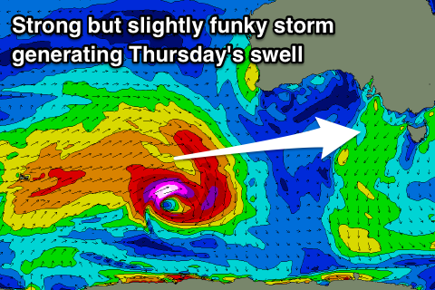
Following the distant polar low linked to the first pulse of small W/SW groundswell, a much more significant storm developed south-west of Western Australia, with a pre-frontal fetch of severe-gale W/NW winds followed by a burst of tight storm-force W/SW winds and trailing strong to gale-force W/SW winds.
This has generated a fun pulse of W/SW groundswell that is a touch tricky to forecast owing to the funky structure of the storm but we should see it arriving later Wednesday and peaking Thursday to a fun 3ft on the Surf Coast swell magnets and 4-5ft to the east, if not for the odd sneaky bigger one.
Winds look N/NW tending W/NW on the Surf Coast, keeping conditions clean all day, with an early N'ly likely on the Mornington Peninsula, but we'll have to review this Wednesday.
Winds for Friday are a little unsure at this stage but we're likely to see some form of N'ly hopefully favouring the exposed beaches as the swell eases.
From the weekend we're likely looking at a flurry of strong mid-latitude frontal systems pushing through under the country. We'll see plenty of W/SW swell from Saturday through next week, but with varying strength and winds, check back here Wednesday for a clearer idea on the sizes and local conditions.
Comments
Oh good (sorry NB and GF) a sort of return to normal west to east wind/swell flow later into the week/weekend, albeit with very marginal swell but still, go away devil wind 'n' swell combo's, it too early for that shit, it's still only bloody October.
just a few E wind days keep me happy G. I can tolerate this, aside from the flatness