Fun end to the week, upgrade in swell for the weekend, but windy

Victoria Forecast by Craig Brokensha (issued Wednesday 16th August)
Best Days: Surf Coast Thursday and Friday, Saturday as the swell builds but before before winds change, Surf Coast next Tuesday/Wednesday
Recap
A reinforcing W'ly swell and good conditions across protected spots on the Surf Coast yesterday with surf in the 3ft+ range, poor to the east.
The swell has dropped back slightly into this morning leaving smaller 2ft to occasionally 3ft waves on the Surf Coast and stormy 4-6ft to the east.
We should see some new W/SW building this afternoon as a strong mid-latitude low pushes across us, but not to the size shown on the models. More on this below.
Today’s Forecaster Notes are brought to you by Rip Curl
This week and weekend (Aug 16 - 19)
A low point in swell was seen this morning, but a strong low that's currently pushing across us has generated a fetch of severe-gale W/NW winds right off our doorstep.
This has produced a new W'ly groundswell that should start building this afternoon, reaching 3ft+ across the Surf Coast by dark and a more consistent 6ft to the east as winds remain strong from the W/NW.
Trailing this severe-gale W/NW fetch, a slightly better aligned but still very west in nature fetch of similar strength winds were generated through the Bight, weakening while moving in and across us this evening.
A mix of acute W'ly groundswells have resulted, with a peak due early tomorrow, easing into the afternoon and further Friday.
The models are over-forecasting the size and incorrectly combining all these swells, but we can expect surf in the 4ft range across magnets on the Surf Coast tomorrow, much smaller in more protected spots, with 6ft+ sets to the east along with W/NW tending W winds. There may be periods of W/SW winds at times through the day, but protected spots should remain mostly clean.
Friday will be much cleaner with a NW offshore and easing 3ft sets at magnets (more so 2-3ft) on the Surf Coast and 4-5ft to the east.
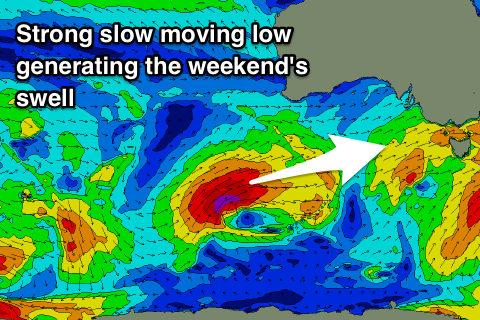 Our low point on Saturday morning is still expected, but the strengthening polar front mentioned last update is looking to come in with a bit more strength over the weekend.
This system is currently south-west of WA and will project slowly towards us over the coming days, generating gale to severe-gale W/SW winds in our far swell window, weakening as it nears closer.
What we should see is an increase in mid-period and W/SW groundswell energy through Saturday afternoon with gusty W/NW tending W/SW winds, with a peak due Sunday though with poor S/SW winds.
Size wise the Surf Coast looks to build to 3-4ft by dark Saturday but with the W/SW onshore wind, coming in at 4-5ft+ on Sunday.
The low is due to move north-east on Monday but winds will linger onshore from the S/SW, tending more W/SW through the day as the swell eases.
A secondary polar low may generate a new S/SW groundswell for Tuesday/Wednesday with more favourable winds, but we'll have another look at this on Friday.
Comments
2018, the year of the westerly swells! Well that's what it feels like here on the Surfcoast.
Finally, it was lined-up this morning. 3ft set waves were grinding down the surfcoast reefs, with speed and shape. Now I remember why I luv surfing, yeeeewww!
Awesome.