Increasing westerly energy ahead of a large S/SW on the weekend

Victoria Forecast by Craig Brokensha (issued Wednesday 13th June)
Best Days: Surf Coast Thursday afternoon, Friday, Saturday morning, early Sunday, exposed beaches Tuesday
Recap
Average surf yesterday with a very acute W'ly swell providing no real size through the morning, while a touch more energy was seen into the afternoon to 2ft on the sets across the Surf Coast as winds remained favourable.
This morning the swell and conditions were better with 2ft to occasionally 3ft sets on Surf Coast magnets with favourable winds, while the Mornington Peninsula was bumpy, better on Phillip Island. We'll see the swell ease through the day as winds hold from the N/NW until early afternoon, shifting NW thereafter.
Today’s Forecaster Notes are brought to you by Rip Curl
This week and weekend (Jun 14 - 17)
Want to receive an email when these Forecaster Notes are updated? Then log in here and update your preferences.
The end of the week will continue the theme of tricky westerly swell energy with favourable winds for the Surf Coast.
A low point in swell is due tomorrow morning to a small 1-2ft on the Surf Coast and 3-4ft to the east, but through the afternoon a fun new mid-period W/SW swell is due to fill in.
This swell has been generated by a weakening polar low projecting towards WA through our western swell window, weakening while passing through the Bight last night.
We should see the Surf Coast build to 2-3ft through the mid-late afternoon with 4-5ft+ sets to the east under a gusty NW tending N/NW breeze.
The swell should hold a similar size into Friday morning under fresh to strong NW winds, shifting more W/NW through the day as a complex low starts to drift over us.
 The low will form as a polar front projects up into South Australia tomorrow, with a low pressure centre developing and then drifting south-east across us on Friday.
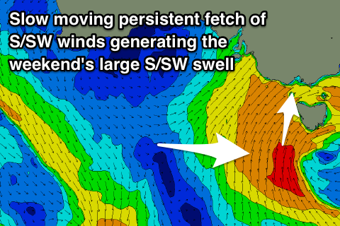
This will see a fetch of strong to gale-force W/SW winds developing through Bass Strait, with a better SW-S/SW fetch developing south-west of us.
We'll likely see building levels of W/SW swell through Friday afternoon but only to 3ft or so across the Surf Coast and 4-6ft to the east along with those fresh to strong W/NW winds.
Larger levels of S/SW swell are expected to develop through the weekend as the strong to gale-force S/SW fetch remains positioned in our swell window through Friday and Saturday while slowly projecting up towards us.
We'll see the swell build and strengthen through Saturday from 3-4ft+ early more to 5-6ft on the Surf Coast late in the day and 8ft on the Mornington Peninsula, easing back from 6ft and 8ft+ respectively Sunday morning.
The slow moving nature of the low will help create favourable winds on Saturday morning out of the W/NW, though the surf will likely be a bit raw, deteriorating as winds shift W/SW into the afternoon.
Early Sunday we're also likely to see winds out of the W/NW, shifting S/SW mid-morning as the low moves east.
Monday will then be poor as the S/SW swell continues to ease under average and fresh S/SE winds, likely E/NE Tuesday. Some very inconsistent W/SW groundswell is due into early next week from the southern Indian Ocean, building Monday and peaking Tuesday morning.
No major size is expected on the Surf Coast over 2ft to maybe 3ft, but the beaches on the Mornington Peninsula should provide 3-5ft sets with that E/NE breeze. More on this Friday.