Good swells but onshore Wednesday, large S/SW groundswell Friday morning

Victoria Forecast by Craig Brokensha (issued Monday 14th May)
Best Days: Surf Coast Thursday and Friday
Recap
Poor conditions all weekend with large levels of easing S'ly windswell Saturday, moderate in size yesterday as winds continued to slowly abate.
This morning we've seen variable breezes creating clean conditions across all locations with a mix of W/SW and S/SW groundswells to 2-3ft on the Surf Coast and 3-4ft+ to the east.
Today’s Forecaster Notes are brought to you by Rip Curl
This week and weekend (May 15 – 20)
These notes will be brief as Ben is away on holidays.
This morning's mix of swells will ease off later today, but more so tomorrow and a dawn W/NW wind will favour the Surf Coast ahead of a gusty S/SW change mid-morning. We're only looking at small easing 2ft sets across swell magnets.
Lingering onshore winds on Wednesday look to spoil a good mix of distant W/SW groundswell and better SW groundswell.
The distant W/SW groundswell from the Indian Ocean is providing large surf across WA today, but will lose a lot of size once it impacts us, while a better SW groundswell is currently being generated by a vigorous storm that's currently south of the country. A fetch of gale to severe-gale W/SW winds and possible core storm-force winds will generate a moderate sized SW groundswell for Wednesday morning.
We should see good 3-4ft sets on the Surf Coast and 5-6ft+ sets to the east but with a S/SW tending SW breeze. There's a very slim chance for an early W'ly around Torquay, but don't count on it.
 Thursday will become cleaner with a return to a W/NW breeze (likely holding all day) with easing surf from 3ft on the Surf Coast and 5ft range to the east.
Very late in the day a new large long-period S/SW groundswell should be showing its head, but Friday will see the most size.
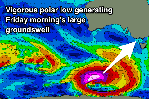
This swell will be produced by an excellent polar low that's due to develop on the polar shelf, south-southwest of WA early tomorrow morning, projecting a fetch of severe-gale to storm-force W/SW winds through our southern swell window right up until passing under Tassie Wednesday evening.
A large, powerful long-period S/SW groundswell will be generated by this severe low, showing on dark Thursday and peaking overnight and easing from the 5-6ft+ range on the Surf Coast Friday morning and 8ft to the east.
Winds look good for the Surf Coast with a morning W/NW breeze, likely tending W/SW through the day as the swell eases.
The weekend isn't looking too flash as a strong high moves in from the west, bringing onshore S/SW winds Saturday as the swell continues to ease and SW breezes Sunday as a new SW groundswell builds, generated by another strong polar low.
Next week is looking a little more promising but more on this Wednesday.
Comments
I think South Channel is having a backwards day?
http://www.bom.gov.au/products/IDV60801/IDV60801.94853.shtml
Maybe the island got blown sideways in last week's swell and wind
Yeah it broke on the weekend with those gale-force winds.