Fun Surf Coast waves ahead of large stormy surf Friday/Saturday

Victoria Forecast by Craig Brokensha (issued Monday 7th May)
Best Days: Surf Coast Tuesday morning, Wednesday and Thursday morning
Recap
Good fun waves across semi-protected spots on the Surf Coast most of the weekend with waves either side of 3ft. This morning our stronger pulse of SW groundswell has provided clean 4ft waves on the Surf Coast and sets to 6ft on the Mornington Peninsula with N'ly offshore winds.
We'll see the swell ease back through the day as winds tend more N/NW and strengthen.
Today’s Forecaster Notes are brought to you by Rip Curl
This week and weekend (May 8 - 13)
Today's strengthening N/NW wind will be associated with a deepening surface trough moving in from the west, with it now forecast to develop into a low while dipping south-east through our swell window.
A very short-lived fetch of SW gales will be generated through our southern swell window this afternoon and evening, and with this we're probably not going to see any visible change in size tomorrow.
Today's SW groundswell is expected to ease as some more distant reinforcing SW energy fills in, produced late last week south-west of WA.
The Surf Coast should hang in around 3ft on the sets, though inconsistent while the Mornington Peninsula 4-6ft. We're still set to see an onshore change overnight but it will be weak and winds look to revert back to the W/NW across the Surf Coast through the morning, more SW tending variable to the east.
Wednesday will see the swell easing across all locations through the morning, best on the Surf Coast with a fresh NW tending W/NW breeze.
Into the afternoon though some new W/SW groundswell is due, followed by a better pulse Thursday.
 Another pre-frontal fetch of W/NW gales pushing in from under WA and the Bight today and tomorrow will be followed by a stronger fetch of W/SW gales pushing through our western swell window tomorrow and Wednesday.
This storm will actually be the final stages of a much stronger polar low that moved through the Indian Ocean over the weekend, generating a long-period and inconsistent swell for Friday/Saturday. This will be overridden by local stormy windswell, but we'll get to this in a sec.
The initial W/SW groundswell for later Wednesday only looks to kick to 2-3ft on the Surf Coast and 4-6ft to the east, while Thursday's swell will be better, building to 3-4ft+ and 6ft to possibly 8ft on the Mornington Peninsula through the afternoon.
Winds are still a little unsure as we're expected to a polar front pushing up from Antarctica bringing a burst of cold air across the south-east of the country, spawning into an intense mid-latitude. At this stage it looks like the Surf Coast will be the pick with a morning W/NW breeze swinging onshore at some stage into the afternoon.
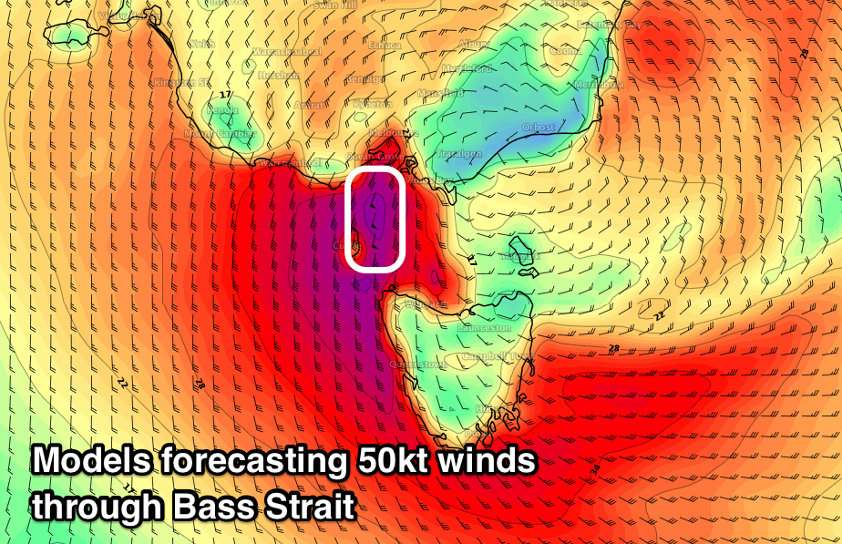
Come Friday the low will push east, with it stalling off the Gippsland coast, bringing torrential rain, snow and gale-force S'ly winds. This will whip up a large stormy S'ly windswell across all locations through Friday, persisting Saturday and easing Sunday as the low starts to move off slowly to the east and weaken.
Under this scenario surfing options will be severely limited and the weather poor. We'll have a closer look at this Wednesday though.
Comments
The expected light variable winds have kicked in across Phillip Island, with surf conditions improving slowly. Still looks pretty chunky though.

Tues midday to arvo, it seemed to crank up a bit, sets were quite a bit overhead by dusk. Some comments on the notch up in size while out. Was that the "more distant reinforcing SW energy fills in, produced late last week south-west of WA." & more to come then a big storm, sounds like a fun week.
Craig with that windspeed map I think you will have to issue a swell alert for Pt Philip Bay. It's gotta be surfable off 50kt southerlies...
Looks like the spike this afternoon was from the very intense low that pushed under NZ. Just strengthened late in Vicco's swell window.
Expect it to be gone tomorrow AM. Only grab that was taken..
I think that low started off as a cyclone way out in the western Indian Ocean, lost strength, drifted down past SW WA, through the Bight and then really ramped up sliding under Tassie. Amazing how far some systems and their effects travel.
Hmmm swellnet graphs calling 8 foot on Friday. Perhaps a slight undercall there Ben? Seaweed claiming 10-16 at Bells (whoa nessy) and they're usually spot on. More waves for me I guess when punters show up undergunned and I'm on the 10'0" Gerry Lopez Elephant.
Seaweed charts are face feet, so they’re calling 5-8ft against our forecast, which is therefore a little under.
Didn’t we go through this last week?
Still waiting for the photos too.
Magic seaweed clearly view it from the underside as it looks bigger from that perspective.
Pro tip - a little manscaping makes it look even bigger.