Building windy surf Friday, better over the weekend for the Surf Coast

Victoria Forecast by Craig Brokensha (issued Wednesday 2nd May)
Best Days: Exposed beaches tomorrow morning, protected spots late Friday, Surf Coast Saturday, Sunday and Monday, selected locations to the east Monday
Recap
Pumping Surf Coast waves yesterday and also good across Phillip Island with a moderate to large sized reinforcing SW groundswell coming in at 3-4ft+ west of Melbourne and the 6ft+ range to the east.
Winds remained favourable for the beaches into the afternoon, though bumpy on the reefs as the swell started to ease.
A much more noticeable drop in size was seen overnight, with clean easing 2ft+ waves on the Surf Coast this morning and 3-4ft waves to the east. We'll see the swell continue to fade through the day as winds hold from the N-N/NE.
Today’s Forecaster Notes are brought to you by Rip Curl
This week and weekend (May 3 - 6)
The end of the week isn't looking too flash, with the surf expected to continue easing into tomorrow leaving tiny 1-1.5ft waves on the Surf Coast and 2ft to maybe 3ft sets on the Mornington Peninsula.
An early fresh N/NE wind will swing N/NW into the afternoon, so the exposed beaches will be best before lunch.
A low point in swell is due early Friday morning, though a strong mid-latitude low will push in through the day, bringing strengthening NW tending W/NW and W/SW winds mid-late afternoon.
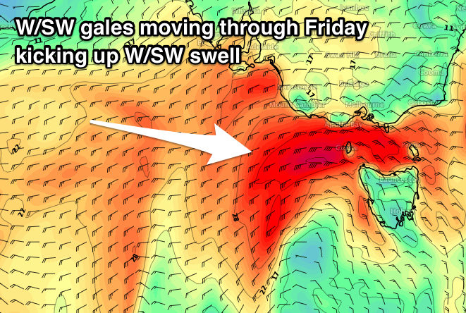 The fetch pushing through our swell window has now been upgraded with gale to near severe-gale W/SW winds due to be projected through Bass Strait from late morning into the afternoon and early evening.
This will kick up a larger increase in W/SW swell through the mid-late afternoon, pulsing solidly to 3-4ft on the Surf Coast at exposed breaks by dark and a stormy 6-8ft on the Mornington Peninsula. Winds will be strong to gale-force from the W though, leaving limited options, especially with the west in the swell.
The front will continue east inro Saturday, with a secondary system producing a weaker fetch of strong W'ly winds through our swell window.
With this we'll see the Surf Coast drop back in size from 3ft to maybe 4ft at exposed breaks, with 6ft+ sets to the east.
A persistent W/NW breeze should keep the Surf Coast reefs clean all day, though exposed smaller surf in these protected spots with the west in the swell.
Moving into Sunday we should start to see some new W/SW swell building across the region followed by fun SW energy early next week.
A strong frontal progression moving in from the west from Friday will see a fetch of pre-frontal W/NW gales generating a new W/SW groundswell for Sunday, with a better aligned fetch of slightly stronger W/SW winds generating a bigger SW groundswell for later in the day and more so Monday.
The Surf Coast Sunday looks to be around 3ft at exposed breaks, with 4-6ft sets to the east, while a further kick later should be seen, peaking through Monday to 4ft and 6ft+ respectively.
Winds on Sunday will be best for the Surf Coast again with a W/NW tending variable breeze, while Monday should be workable across a number of regions with a moderate to fresh N/NW breeze holding most of the day.
This freshening N/NW'ly will be ahead of a strong surface trough, with a change due overnight, bringing poor S/SE winds into Tuesday as some longer-range and less consistent SW groundswell fills in. More on this Friday though.