Clean easing surf over the coming days, slow next week

Victoria Forecast by Craig Brokensha (issued Wednesday 18th April)
Best Days: Both coasts Thursday morning, beaches Friday morning, east of Melbourne Monday
Recap
Large levels of SW groundswell energy continued across all locations yesterday with poor conditions through the morning, but onshore winds eased into the afternoon creating cleaner and improving waves on the Surf Coast reefs and the Phillip Island region.
This morning the swell was still in the moderate to large range with a large S/SW groundswell keeping the Mornington Peninsula up around 6ft to occasionally 8ft, with 4-5ft+ waves on the Surf Coast.
Conditions are much cleaner across all locations with winds from the north-east quadrant, and best on the beaches.
Today’s Forecaster Notes are brought to you by Rip Curl
This week and weekend (Apr 19 - 22)
This morning's strong S/SW groundswell will start to ease through the day, dropping away further through the end of the week, but conditions tomorrow morning are looking great for most locations.
Local offshore winds (N/NW Surf Coast and N/NE Mornington Peninsula) are expected through the morning with easing sets from 3ft to occasionally 4ft on the Surf Coast and 4-5ft+ on the Mornington Peninsula. SE sea breezes will develop early afternoon, so get in through the morning.
Winds will revert back to the N/NE on Friday favouring the beaches again as the swell continues to ease from a small 2ft on the Surf Coast magnets and 3ft range to the east.
As touched on in Monday's update, no new swell is really expected Saturday, besides a very long-range, small and inconsistent long-period W/SW groundswell building Sunday.
 The Surf Coast will become tiny on Saturday with possible leftover 2ft sets on the Mornington Peninsula under a favourable morning N/NE breeze.
The long-range W/SW groundswell will provide oversized surf to WA and Indo but by the time it reaches our coasts there's hardly any size due to be left, with the Mornington Peninsula expected to build to a very very inconsistent 3ft on the sets into the afternoon, if not a touch bigger late. The Surf Coast will unfortunately remain tiny and W/SW tending SE winds will create average conditions.
The swell looks to peak Monday to 3ft to occasionally 4ft on the Mornington Peninsula and 1ft to maybe 2ft on the Surf Coast under favourable N/NE tending N/NW winds.
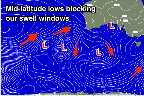
Longer term mid-latitude lows in the Bight and off WA will block our main swell windows with no major surf due until next weekend, more on this Friday though.