Large swells to continue as winds do a full 360

Victoria Forecast by Craig Brokensha (issued Monday 16th April)
Best Days: Surf Coast early Tuesday, beaches that will handle the swell Wednesday mid-late morning, Thursday, Friday exposed beaches
Recap
Tiny and windy most of Saturday across the Surf Coast with some small swell later in the day, but through Sunday we saw the swell kick through the day, building from the 4-5ft range in the morning up to the 5-6ft+ range at magnets as conditions straightened out and improved.
The Mornington Peninsula was poor with large stormy surf developing, best in protected spots.
This morning the swell was hanging in around 4-6ft on the Surf Coast with pumping waves under offshore winds, and a choppy 6-8ft on the Mornington Peninsula.
Today’s Forecaster Notes are brought to you by Rip Curl
This week and weekend (Apr 17 - 22)
Looking at the coming days, we've got more large surf due to continue across the region with a strong mid-latitude low moving through our swell window last night and early this morning keeping large surf hitting the coast all day today.
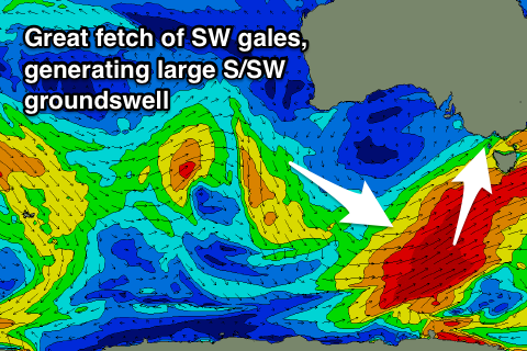 Our polar fetch of SW gales is looking a little better, with an elongated sustained and strengthening fetch through our southern swell window today expected to generate a large S/SW groundswell for later tomorrow and Wednesday morning.
So tomorrow morning we should see today's reinforcing swell hanging in around 4-5ft+ on the Surf Coast with 6-8ft sets to the east, while a stronger kick is expected later in the day, peaking Wednesday morning to 5-6ft on the Surf Coast and holding 6-8ft to the east with that bit of south in the direction.
The swell should ease through the day, dropping from 3ft to occasionally 4ft on the Surf Coast Thursday and 4-5ft+ on the Mornington Peninsula.
Winds tomorrow look average with SW breezes expected across all locations, likely W/NW early around Torquay.
Wednesday is a tricky one with winds due to swing E/NE to N/NE through the day before sea breezes kick in, but the large swell will leave only limited surfing options.
Thursday looks super fun across all locations with local offshore winds (N/NW Surf Coast and N/NE Mornington Peninsula) ahead of mid-afternoon sea breezes.
Come Friday the swell will continue to drop and become small, with a W/SW swell for the afternoon hardly offering any size across the Surf Coast, generated by a small mid-latitude low in the Indian Ocean. The Mornington Peninsula should hang around 2-3ft, though inconsistent and a mid-latitude low forming in the Bight looks to swing winds back to the N/NE.
Unfortunately there's no decent swell due through the weekend as the mid-latitude low puts a block on our main swell windows, but some very very inconsistent long-period energy from the Indian Ocean will provide small sets across exposed beaches Sunday and Monday.
This swell is being generated by a significant storm in the southern Indian Ocean, but with the large travel distance no size will be left when it arrives on our shores.
A building trend is expected through Sunday reaching a very inconsistent 3ft+ or so later in the day on the Mornington Peninsula, easing slowly through Monday. Winds are a little dicey but look OK for the beaches, but we'll confirm this Wednesday.
Comments
Fun lil' peelers at Lorne this AM.
