Easing surf, cleanest on the beaches Saturday morning

Victoria Forecast by Craig Brokensha (issued Wednesday 3rd January)
Best Days: Surf Coast Thursday morning, both regions Friday morning, exposed beaches Saturday morning
Recap
Another morning of fun waves across the Surf Coast yesterday with clean surf in the 3ft range (3-4ft at 13th Beach) while locations to the east we less than ideal. This morning the swell was continuing around the same size, cleanest on the Torquay reefs early, though onshore winds have now moved through.
Today’s Forecaster Notes are brought to you by Rip Curl
This week and weekend (Jan 4 - 7)
The surf is hanging in across the region today, owing to a reinforcing SW swell produced by a front projecting towards us the last couple of days.
We should see similar sized sets hanging in tomorrow morning to 3ft on the Surf Coast and 4-6ft on the Mornington Peninsula during the morning before easing through the day, smaller into Friday morning.
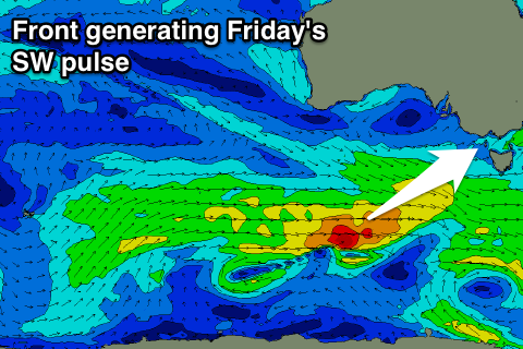
A fun pulse of new SW swell is due through Friday though, generated by a small burst of W'ly gales south of WA that will continue east over the coming days. We should see the Surf Coast kicking to 2ft+ with 3-5ft sets on the Mornington Peninsula.
 A morning W/NW-NW breeze will again favour the Surf Coast tomorrow morning, but the beaches to the east will remain average.
More variable winds are likely Friday but the expected NE'ly doesn't look to develop to the east any more, so conditions will be cleaner but still likely lumpy across the exposed beaches to the east. The Surf Coast should be nice and clean though.
Saturday will finally see an offshore morning N/NE breeze kick in for the beaches (NW into the afternoon) and Friday's small spike in swell should ease back from 2ft on the Surf Coast and 3ft to maybe 4ft on the Mornington Peninsula.
Into Sunday we'll see a building and strengthening W/SW swell, peaking Monday morning, generated by a broad but relatively weak front pushing through the Bight and across us Saturday evening.
With the front, Sunday will be poor with onshore S'ly winds and building surf, while Monday may see winds tip back NW as another front approaches. Size wise we're not looking at much above 2ft to occasionally 3ft on the Surf Coast and 4-5ft on the Mornington Peninsula.
Behind this there's a bit more W/SW energy on the cards but winds look poor. More on this Friday.