Easing surf with east winds, cleaner early next week but small

Victoria Forecast by Craig Brokensha (issued Friday 10th November)
Best Days: Both coasts Sunday and Monday mornings, Tuesday morning Surf Coast, Wednesday morning Surf Coast, Thursday both coasts
Recap
Fun waves across the Surf Coast yesterday with variable winds and easing sets from 2ft+ at exposed breaks (2-3ft 13th Beach) before sea breezes kicked in. The Mornington Peninsula was lumpy and not ideal early, better mid-late morning before sea breezes kicked in.
This morning, the surf was around a similar size with variable winds again creating OK but not great conditions. Our new S/SW groundswell was a little delayed but is now building across the state with fun conditions under those variable winds.
This weekend and next week (Nov 11 - 17)
Today's building S/SW groundswell is expected to peak this afternoon across both coasts to 3ft on the Surf Coast and 4-5ft on the Mornington Peninsula, if not for the odd bigger bomb at times. Sea breezes will create average conditions though.
We should see the swell ease back from a similar 3ft and 4-5ft respectively tomorrow morning and a light to moderate morning E'ly breeze will favour the beaches across both regions before SE sea breezes kick in.
Similar but slightly stiffer winds are due through Sunday as the swell becomes smaller, back to a small 2ft on the Surf Coast and 3-4ft on the Mornington Peninsula. There'll also be some poor SE windswell mixed in across the Surf Coast owing to the persistent E-SE winds.
 Our small and inconsistent W/SW groundswell for later Sunday and more so Monday is still expected, generated by a strong but short-lived mid-latitude low in our far swell window, west-southwest of WA.
Only small and inconsistent sets are due from this swell, coming in at an infrequent 2ft at swell magnets on the Surf Coast Monday morning and 3-4ft on the Mornington Peninsula.
Winds will become much better for the exposed beaches across the state though with a dawn E/NE breeze, tending N/NE through the morning before sea breezes kick in.
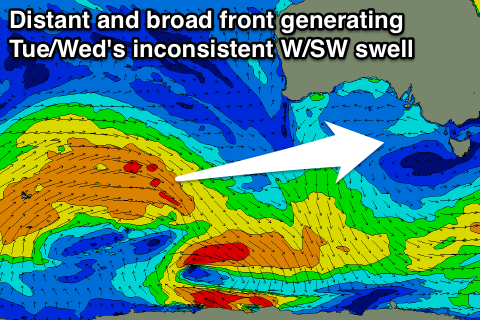
A secondary inconsistent reinforcing W/SW swell is due through Tuesday and Wednesday, produced by a broader but weaker polar front developing behind the mid-latitude low, but this will only provide infrequent 2ft set waves on the Surf Coast and 3ft to occasionally 4ft waves on the Mornington Peninsula.
Winds will be great again for swell magnets though with a N/NE tending variable breeze (possibly tending N/NW on the Surf Coast) Tuesday and variable winds Wednesday morning ahead of a change.
This change will be in the form of a surface trough, with poor onshore winds expected to hold into Thursday and possibly even Friday with fading levels of small groundswell (not the best outlook at all).
Longer term there's nothing too significant on the cards at all besides a small inconsistent SW groundswell for next weekend. More on this Monday, have a great weekend!