Great few days of surf ahead for all locations

Victoria Forecast by Craig Brokensha (issued Wednesday 20th September)
Best Days: Both coasts Thursday morning, Friday, Saturday
Recap
An impressive and large long-period W/SW groundswell filled in yesterday across the coast though the size was a touch under expectations and more in the 5-6ft range across magnets on the Surf Coast and 8ft to the east. Conditions were good in protected spots through the morning and average into the afternoon.
This morning was the day to surf and the reinforcing SW groundswell has come in right on cue with pumping 4-5ft+ waves on the Surf Coast and 6-8ft waves across the Mornington Peninsula.
The swell should ease slowly through the day as winds hold from the N/NW all day on the Surf Coast and tend N/NE east of Melbourne.
This week and weekend (Sep 21 – 24)
Today's strong SW groundswell will ease through the day and further overnight leaving much smaller surf across the state tomorrow, back to 2ft+ across the Surf Coast and 3-4ft+ on the Mornington Peninsula.
Conditions will be great for exposed breaks with a morning N/NE'ly east of Melbourne, tending NW into the afternoon, while the Surf Coast will see N/NW tending NW breezes.
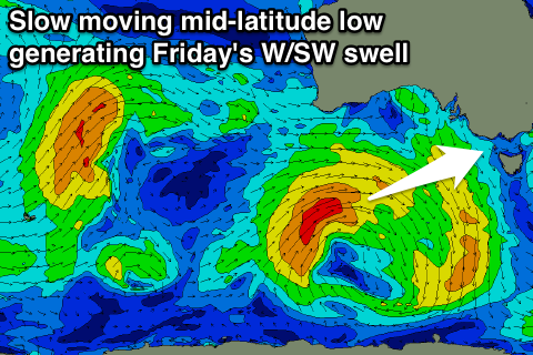 Our new W/SW swell for Friday is still on track, with slow moving mid-latitude low from west-southwest of WA now sitting south of the state, continuing to aim a good fetch of strong W/SW winds through our western swell window. The low will continue to weaken through today while moving through our south-western swell window, resulting in a slower easing trend through Saturday.
We should see the Surf Coast come in around 3ft Friday with 5-6ft sets on the Mornington Peninsula, easing slowly from 2-3ft and 4-5ft Saturday morning.
Light local offshore winds should create clean conditions across both regions Friday morning ahead of mid-late afternoon E/SE sea breezes.
Saturday looks good across the beaches again early with a N'ly breeze, but this will tend N/NW and then W/NW into the afternoon.
Come Sunday there isn't expected to be much swell left across the coast with 1-2ft waves at magnets on the Surf Coast and 2-3ft waves to the east.
Another strong mid-latitude low pushing towards and across us through the day will bring strong NW tending W/NW winds and a possible afternoon increase in mid-period W'ly swell.
The size of this swell depends on how far north the low sits, and if it's too north we'll see nothing, but if further south we'll see some decent size.
The models are agreeing on somewhere in between at this stage which isn't ideal.
We'll probably see sets building to 2-3ft across the Surf Coast by dark, easing off rapidly Monday as the low continues east. We'll have to have a closer look at this on Friday though with more consolidation between the models.
Comments
Sea breeze and convection...
Higher land temp means stronger sea breeze?
Complicated question and is mainly linked to how strong the gradient winds are and from what direction. Ignoring this, yes.