Poor Saturday, super fun Sunday, large W/SW groundswell for Tuesday

Victoria Forecast by Craig Brokensha (issued Friday 15th September)
Best Days: Sunday, exposed beaches Monday morning (wind pending), Surf Coast Tuesday, Wednesday
Recap
An increase in mid-period W/SW swell yesterday morning to the 3-4ft range on the Surf Coast, with some stronger groundswell into the afternoon offering larger sets to 4-5ft. Conditions were best for the protected reefs, with W/NW-W winds. East of Melbourne Western Port offered fun waves as the swell kicked into the afternoon.
This morning the swell's dropped off slightly but conditions are great on the Surf Coast reefs again with offshore winds and surf in the 4ft range. Conditions should remain good most of the day as the swell continues to ease.
This weekend and next week (Sep 16 – 22)
These notes will be brief as Ben’s away today.
We've had another change to the strengthening mid-latitude front moving in from the south-west today, with it being upgraded in strength from a downgrade on Wednesday.
 We'll see a tight fetch of severe-gale to storm-force SW winds generated through our southern swell window today, producing a moderate to large sized S/SW groundswell for tomorrow, peaking through the middle of the day.
This will be mixed in with some junky SW windswell associated with the front pushing through bringing poor and gusty W/SW tending SW winds.
We should see 4-5ft surf across the Surf Coast with 6ft to occasionally 8ft sets on the Mornington Peninsula at the swells peak.
This swell will ease rapidly into Sunday due to the low moving east out of our swell window this evening, but some reinforcing SW groundswell from a distant polar low is due.
The Surf Coast should ease back from a fun 3ft+ with 4-5ft+ sets on the Mornington Peninsula as winds improve rapidly. A light N/NW breeze is due on the Surf Coast, with N/NW tending N/NE winds to the east of Melbourne.
Our models are over-forecasting Sunday morning with it combining the new long-period swell with Saturday's easing swells, so keep that in mind.
Monday will be much smaller with strong N tending N/NW winds ahead of a W change into the afternoon.
Hit the exposed beaches for a wave, though the wind may be a bit of an issue.
Into next week, our large long-period groundswell is still on track, with a vigorous low due to develop south-west of WA tomorrow, producing a slow moving and expansive fetch of severe-gale to storm-force W/SW winds through our western swell window.
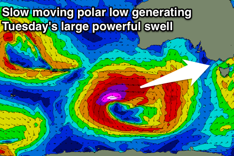 The low will project slowly east towards us while continuing to generate fetches severe-gale to storm-force winds.
We may see this swell kick late Monday but a peak is expected Tuesday morning to a large 6ft to occasionally 8ft on the Surf Coast and 10ft on the Mornington Peninsula, easing slowly through the day.
Winds aren't ideal as a front linked to the strong low moves through Tuesday bringing SW breeze, but Torquay should see a morning W/NW breeze.
Wednesday looks excellent as the swell continues to ease with a N/NW tending N/NE breeze.
We'll have one last look at this swell Monday though. Have a great weekend!