Good waves in protected spots to end the week

Victoria Forecast by Craig Brokensha (issued Wednesday 13th September)
Best Days: Surf Coast Thursday, Friday morning, Surf Coast Sunday, east of Melbourne into the afternoon, exposed beaches Monday, Surf Coast Tuesday
Recap
Good Surf Coast waves yesterday morning with a new SW groundswell, peaking through the middle of the day. A weak onshore change moved through the afternoon, backing off into the late afternoon. The Mornington Peninsula saw good conditions through the morning with solid sets on the beaches.
The swell was still coming in at a good size this morning across both regions, but the Surf Coast was cleanest. A W/SW change is due mid-afternoon along with some building mid-period W/SW swell.
This week and weekend (Sep 14 – 17)
These notes will be brief as Ben’s away today.
A strong mid-latitude front pushing in from the west will bring this afternoon's W/SW change and a moderate to large sized increase in mid-period W/SW swell tomorrow. Some stronger groundswell will fill in through the afternoon, produced by the earlier stages of the front.
We should see 3-5ft waves across the Surf Coast magnets through the morning, building a bit further through the afternoon with 6ft sets likely, while the Mornington Peninsula looks to come in around 6ft+, increasing towards 8ft during the day.
Fresh to strong W'ly winds will favour protected breaks all day, while a better W/NW breeze is due on Friday morning as the swells ease back. Into the afternoon a W/SW change is due, creating average conditions.
This change will be linked to a strengthening mid-latitude front pushing across us, and the dynamics of this system have changed since Monday.
We're now only due to see a relatively weak fetch of strong SW tending S/SW winds projected up and into us Saturday, kicking up some poor mid-period S/SW swell along with fresh to strong W/SW tending SW winds.
The Surf Coast looks to offer messy 4ft surf with 6ft waves on the Mornington Peninsula, easing back into Sunday. We'll see some new long-range SW groundswell in the mix Sunday though, produced by a slow moving polar low through the southern Indian Ocean this week.
We should see inconsistent sets easing from 3ft+ on the Surf Coast and 4-5ft on the Mornington Peninsula as conditions improve considerably. This will be due to a ridge of high pressure moving in, pushed by a vigorous storm firming up south-west of WA (more on this below).
 N/NW winds are due all day across the Surf Coast, while the Mornington Peninsula may see winds tend light N into the afternoon (NW early).
Monday will be smaller again and strengthening N'ly winds will favour the Mornington Peninsula early.
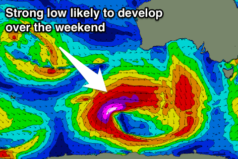
Now, moving into next week, and the vigorous polar low forecast to develop south-west of WA over the weekend is forecast to project a slow moving fetch of severe-gale to storm-force W/SW winds through our south-western swell window.
A large powerful long-period SW groundswell is expected to fill in Tuesday under W'ly winds, but more on this Friday.
Comments
Hi Craig,
What size can we expect in the Torquay region Friday morning?
Thanks.
I'd say in the 4ft range.