Fun easing beachy waves tomorrow, good Surf Coast swell from Sunday

Victoria Forecast by Craig Brokensha (issued Wednesday 26th July)
Best Days: East of Melbourne tomorrow, Surf Coast Friday for small fun waves, Surf Coast Sunday and early Monday
Recap
Pumping waves across the Surf Coast yesterday once an early N/NE wind swung offshore, with a good S/SW groundswell providing clean ruler edge 3-4ft surf. Selected breaks on the Mornington Peninsula were OK but in general it was hard to find a good wave.
Today some new W'ly swell has kept wave heights up above expectations with 3-4ft surf continuing on the Surf Coast with a morning W/NW wind and poor 4-6ft waves to the east.
An onshore change is now moving up the coast and this will create bumpy conditions into this afternoon.
This week and weekend (Jul 27 - 30)
Today's mix of swells will drop right out overnight, with the S/SW groundswell energy fading today, while the W/SW swell will drop with the clearing front this evening.
Expect much smaller surf tomorrow, easing back from 2ft on the sets across the Surf Coast with 3-4ft waves on the Mornington Peninsula.
Winds will be great for exposed beaches though with a N/NW tending N'ly breeze on the Surf Coast and N/NE tending N breezes east of Melbourne, increasing through the afternoon.
A mid-latitude front pushing through Thursday evening and early Friday should kick up some new W'ly swell, but only to 2ft+ or so on the Surf Coast through the day and 3-5ft on the Mornington Peninsula. Winds look as if they'll hold from the W/NW all day as another strong storm approaches from the west, while Saturday will be small to tiny with fresh to strong N'ly winds.
 Now we're closer to the W/SW groundswell event due into Sunday we can look a little closer at the specifics.
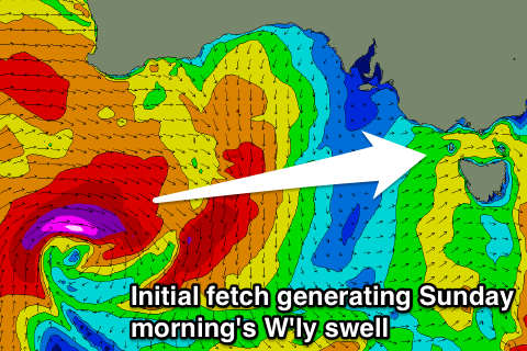
A vigorous mid-latitude storm is forecast to develop west-southwest of WA over the coming days, with an initial fetch of severe-gale to storm W/NW winds in our swell window early Friday due to produce a long-period W'ly swell for Sunday morning.
This swell will then be replaced by a better aligned W/SW groundswell into the late afternoon and Monday morning, produced by a broad fetch of severe-gale W/SW winds moving towards us Friday evening through Saturday before weakening west of us Sunday.
Sunday morning's swell should come in around 3-4ft+ on the Surf Coast, with 6ft+ waves on the Mornington Peninsula.
A stronger kick in size is then due on dark to 5-6ft and 8ft respectively, easing from 4-6ft and 8ft respectively Monday morning.
Conditions are looking great all day Sunday for the Surf Coast with a fresh NW'ly tending W/NW breeze, with S/SW winds across most spots Monday besides an early W/NW'ly around Torquay.
Tuesday looks onshore across all locations as the swell continues to ease, but more on this Friday.