Good waves Saturday, onshore with a mix of three strong swells building Sunday

Victoria Forecast by Craig Brokensha (issued Friday 16th June)
Best Days: Surf Coast Saturday and dawn Sunday, Surf Coast Monday and Tuesday, possibly east of Melbourne Tuesday
Recap
Excellent waves across the Surf Coast yesterday and today with 3-4ft surf on the reefs with all day offshore winds. Locations to the east of Melbourne have also been good with more size and N'ly breezes.
We should see the swell ease slightly this afternoon as winds remain good and tend variable.
This weekend and next week (June 17 – 23)
We'll continue to see good waves on the Surf Coast tomorrow, a bit wind affected to the east.
The swell will drop slowly as a reinforcing swell fills in, produced by a good pre-frontal fetch of W/NW gales through our swell window Wednesday.
The Surf Coast should continue to see 3ft sets, with 4-5ft+ waves on the Mornington Peninsula under a NW breeze, tending more W/NW into the afternoon.
 Our strong mix of three different swells for Sunday is still on track, but an onshore change is now due shortly after dawn.
The first swell from the W/SW has been produced by a stronger fetch of W/NW gales moving under WA and the Bight yesterday and should provide 3ft sets on the Surf Coast during the morning with 4-6ft waves on the Mornington Peninsula.
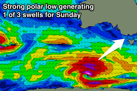
A stronger and broader fetch of severe-gale polar W/SW winds to our south-west last night and this morning is generating a larger long-period SW groundswell which is due to arrive mid-morning, providing 3-5ft sets on the Surf Coast and 6ft+ waves on the Mornington Peninsula.
One final SW groundswell will be produced by a deepening low tracking in quickly from the east tomorrow afternoon and evening, with a burst of severe-gale to storm-force SW winds generated in our swell window.
4-5ft and 6-8ft surf respectively across both coasts is due off this system into the afternoon, but as touched on above, conditions will be average with a fresh SW change, easing later into the afternoon.
Also the three different swells will overlap and create funky and less than ideal double-ups.
This weird mix of swells will ease into Monday but be much cleaner with a persistent NW breeze. The Surf Coast should ease from the 4ft range, with 6ft+ sets to the east.
A reinforcing W/SW swell is due into Tuesday, produced by another pre-frontal fetch of W/NW gales moving under the country on Sunday and with this we should see sets persisting around 3ft on the Surf Coast and 4-6ft on the Mornington Peninsula.
Winds are due to tend a little more N/NW keeping the Surf Coast clean (possibly N'ly at times on the Mornington Peninsula), but we'll review this Monday.
Longer term we're looking at a more typical winter frontal progression firing up mid-late week, producing large surf next weekend, but more on this Monday. Have a great weekend!
Comments
Coupla smoking sets at 13th this AM.
Impressive!