Great weekend, more swell next week

Victoria Forecast by Craig Brokensha (issued Friday 26th May)
Best Days: Both coasts Saturday, Surf Coast Sunday, Monday and Tuesday morning, Surf Coast again Thursday
Recap
Clean conditions across the Surf Coast yesterday with small 1-2ft waves through the morning, building to a better 2-3ft during the day with a new pulse of W/SW swell. The Mornington Peninsula also increased in size but conditions were average and bumpy.
Today the swell is back just a touch, and conditions are best around Torquay with a W/NW offshore.
A strong new W/SW groundswell has just hit the Cape Sorell and Point Nepean buoys and we should see this building strongly this afternoon as winds become variable from the N'th. This should create clean conditions across most locations, well worth the late surf.
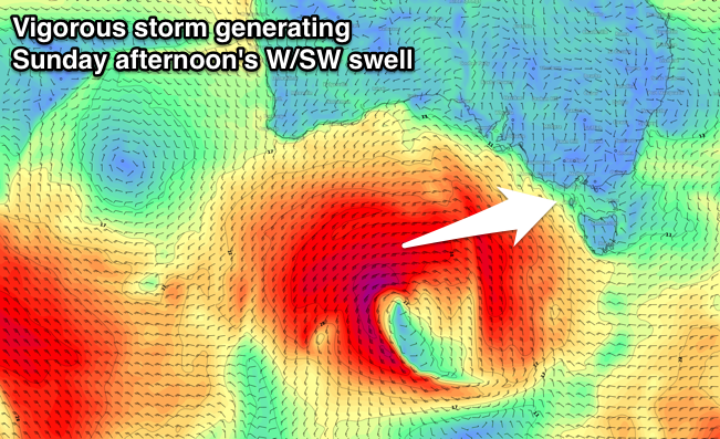
This weekend and next week (May 27 – Jun 2)
This afternoon's W/SW groundswell should reach 4-5ft by dark across swell magnets on the Surf Coast and 6-8ft on the Mornington Peninsula as winds tend variable.
Into tomorrow, the beaches will be best as the swell eases back form 3-5ft and 6ft+ respectively under a gusty N'ly wind.
 Our solid new W/SW groundswell event for Sunday is still on track.
Currently south of WA a strong mid-latitude front is deepening, and we'll see a fetch of W/SW gales projected through our western swell window through today and tomorrow, before the system weakens Sunday.
A moderate to large W/SW groundswell should result, building through Sunday morning and reaching 4-5ft across the Surf Coast later in the day at swell magnets and 6-8ft on the Mornington Peninsula again.
Winds will be best for the Surf Coast with a fresh W/NW tending W'ly breeze, while Monday looks excellent all day with an approaching front producing W/NW winds, tending NW late.
The swell should ease back from 3-5ft and 6ft to occasionally 8ft respectively, smaller into Tuesday morning with a fresh N/NW breeze ahead of a gusty W/SW change mid-late morning.
This change will be associated with a vigorous polar front projecting up and into us early-mid next week, with a fetch of gale to severe-gale SW winds developing south of WA and moving right up close to us Tuesday afternoon and evening.
The models are still moving around regarding the structure of this system but we should see a moderate to large SW groundswell filling in Wednesday, peaking through the afternoon. The size could be anywhere 4ft to 6ft on the Surf Coast, so check back here Monday for more on this.
Winds looks average with a gusty SW-S/SW breeze, but the Surf Coast should see an early W/NW'ly.
A return to offshores is expected on Thursday as the swell eases, but we'll have a closer look at this next week. Have a great weekend!
Comments
Sorrell Tp has spiked to 18sec, but in relation to forerunners and actual swell, how can you differentiate between the two? Would the the Tp/Hs have to rise in correlation to indicate the swell?
This one's tricky as the storm continued to travel east after the strong winds that generated the long-period swell in the Indian Ocean. So we're seeing a mix of mid-period and long-range energy building at the same time.
Bit of a jump here, now it's a race between the swell really kicking and the sun setting.
late!
Good clean sets.
You can see the overlapping mid-period and long-period swell in the shot below..
Definitely plenty of that Portsea yesterday. The swell also had alot of punch. Every duckdive was bitch
What the go with the wams at the moment Craig haven the updated since last Sunday, are you using new ones in the forcast notes is there a link to those ? Like ones up above
We're having a few problems with our wave model, and are trying to get it back up and running. Sorry for the inconvenience.
Rip to des watson from geelong who lost his life today at gunnamatta beach and to the boys who went out to get him and tried so hard to get him back to shore brave boys brave