Excellent weekend on the Surf Coast

Victoria Forecast by Craig Brokensha (issued Friday 17th February)
Best Days: Surf Coast Saturday morning, Surf Coast Sunday, Torquay early Monday, east of Melbourne Tuesday
Recap
A slow start to yesterday with small surf and bumpy conditions but the strong new S/SW groundswell kicked late morning, with solid sets into the afternoon and evening across the state as winds remained workable for keen surfers.
This morning was the pick though with pumping 3-5ft waves on the Surf Coast and 6ft+ waves on the Mornington Peninsula, best in protected spots.
This weekend and early next week (Feb 18 - 24)
With pumping waves today, we look ahead into the weekend and it's looking like a classic autumn/winter weekend of surf but in summer.
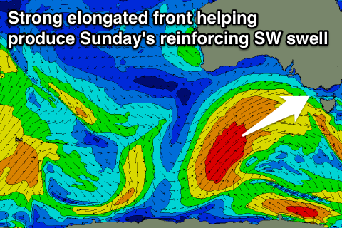
As talked about the last few updates, a vigorous polar front which formed south-west of WA, has been moving slowly through our south-western and western swell windows while pushing up towards the Bight.
The front is continuing to generate a vast fetch of SW gales through our south-western swell window and will do while projecting towards us today and tomorrow, weakening slightly.
What we'll see is a large long-period W/SW groundswell building through tomorrow, remaining large Sunday out of the SW.
 Torquay should see surf in the 4ft range tomorrow morning, building towards 6ft on the sets into the afternoon with the Mornington Peninsula building from 6ft+ to 8-10ft.
The SW swell should keep 4-6ft waves hitting the Surf Coast most of Sunday, dropping later, with 8ft+ waves on the Mornington Peninsula.
The great thing about the slow moving frontal system is that we'll see winds now remain favourable most of Sunday as the front pushes up into the south-east of South Australia.
Tomorrow a morning W/NW breeze will favour the Surf Coast, swinging W/SW through the afternoon, but Sunday should see W/NW winds all morning, into the early afternoon before swinging W/SW later.
Monday now looks to be the day where a general onshore SW airstream is blowing across the coast, early W'ly around Torquay.
The surf will be smaller and easing from 3-5ft or so on the Surf Coast and 6-8ft on the Mornington Peninsula.
Come Tuesday the Mornington Peninsula will be the go with easing surf around 4ft and a morning variable tending NE breeze.
As touched on last update some good new W/SW groundswell is due late week from another strong polar frontal progression under the country. This should generate a moderate to large W/SW swell for Friday, but more on this Monday. Have a great weekend!
Comments
Thanks for the forecast Craig. Tbh I hadn't really been looking and this morning was a pleasant surprise. Really felt like autumn with warm water.
Yay the circus will be in town this weekend! And every other surf coast town.
As long as everyone shows the appropriate etiquette. All should go ok, just sad when there are too many self proclaimed ring-masters trying to direct the show,
Looked like it was an epic weekend of waves!