Small clean swells throughout the week; large from the south Sunday onwards

Sydney, Hunter and Illawarra Surf Forecast by Ben Matson (issued Monday 11th June)
Best Days: Tues: offshore winds and a fun peaky though steadily easing SE swell. Wed/Thurs: small but clean with inconsistent E'ly swells. Sun/Mon/Tues: large S'ly swells, mainly SW winds.
Recap: Saturday was tiny and clean, whilst Sunday saw freshening southerly winds and building S/SE windswells across the coast. This culminated in a much better round of waves for some coasts this morning, with mid-range SE swell reaching a peak around 4ft and winds remaining light offshore mainly north from Sydney (a S/SW flow persisted south of the harbour this morning, before settling north of the harbour this afternoon).
Today’s Forecaster Notes are brought to you by Rip Curl
This week (June 12 - 15)
Want to receive an email when these Forecaster Notes are updated? Then log in here and update your preferences.
Sunday's small Tasman Low has already reached a peak in strength, and is now easing. Consequently surf size will ease steadily through Tuesday, though there should still be some reasonable sets on offer at dawn, across exposed beaches, in the 3ft+ range, easing to 2-3ft throughout the day and it'll be smaller at southern ends.
Conditions look great with light offshore winds for the early session; moderate northerlies are possible after lunch preceding an overnight westerly change.
The rest of the week will remain very clean under a predominant westerly airstream, but there’s not a lot of size potential. However, we have two small swell sources expected to provide energy through Wednesday and Thursday.
The first is a tropical low that developed near Fiji on Saturday, and has since drifted south through our E/NE swell window. Whilst not especially strong, it did display a reasonable fetch and we’re likely to see very inconsistent 2ft sets at times through the middle of the week.
Additionally, a small E/SE fetch currently exiting western Cook Strait should supply small surf through the middle of the week. However, both events won’t be very large and there’ll be long breaks between waves - it’s certainly not worth rescheduling your diary around. All swell energy is expected to taper off into Friday, leaving us with tiny waves to finish the working week.
This weekend (June 15 - 16)
An amplifying node of the Long Wave Trough will impact the south-eastern corner of the country later this week, bringing about a cold snap to the southern states, and a period of gusty W/NW tending W/SW winds across Southern NSW.
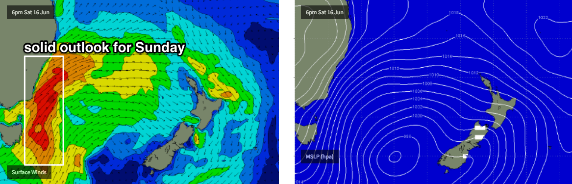
The parent low associated with this pattern is not expected to enter the Tasman Sea - and thus our south swell window - until early Saturday. So, this outlook suggests we’ll start the weekend on a small, if not tiny note, ahead of a building S’ly swell into the afternoon that’ll become quite large (and wind affected) into Sunday as S/SW gales develop in the western Tasman Sea, parallel to the Southern NSW coast.
Saturday afternoon is not expected to see any great size at this stage, but Sunday’s on track for solid 6-8ft surf at south facing beaches with smaller waves elsewhere due ot the direction. Winds should remain SW (rather than S’ly) so there’ll be workable options at most coasts. Let's fine tune things on Wednesday.
Next week (June 17 onwards)
It looks like our upcoming Long Wave Trough pattern will remain slow moving as it traverses the Tasman Sea, allowing a series of strong secondary fronts to wrap around its western flank, delivering a sustained period of large southerly swell through the first half of next week. More on this in Wednesday’s update.
Comments
Small late slabs at Shark Island.


Fun late lines in Newy too.

What's that swell ?
Oh yeah 1.4m ese looks about right.
I’d say the swell punched a bit above forecast yesterday. Was a pleasure to be in the water.
Which coast? Looked about 2-3ft to me all day, though forecast had 3ft+ early.
illawarra. it was 4 ft sets and consistent as, i got out at lunch time.
It was 4-5ft on the south coast yesterday morning with consistent sets. It started to slow up around midday.
Not overly surprised, fetch was further south and aimed better towards that region. Thanks for the feedback!