Thursday onwards looking fun out of the E/NE

Sydney, Hunter and Illawarra Surf Forecast by Ben Matson (issued Monday 2nd April)
Best Days: Thurs/Fri/Sat/Sun: varying degrees of inconsistent E/NE swell. Fri and Sat seem to be the pick at this stage.
Recap: Easing S’ly winds caused a few problems on Saturday but there remained a small level of E/NE swell across the swell. Sunday saw the E/NE swell persisting, if a shade smaller, but a small S’ly swell glanced the coast offering 2ft+ sets throughout the day, and conditions were OK with light winds in the morning, with moderate but freshening N’lies into the afternoon. Both swells held into this morning and winds have mainly been light and variable for much of the day.
Today’s Forecaster Notes are brought to you by Rip Curl
This week (Apr 3rd - 6th)
There’s no major changes to the overall synoptic pattern discussed in Friday’s notes.
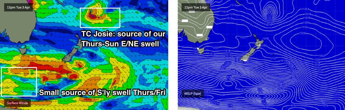
A broad high pressure system through the Tasman Sea will prevent any major weather systems from developing in our near swell window this week, however we have a few sources on the outer edges that will send groundswell our way.
First of all, the anchored trade flow through the Northern Tasman Sea will supply a small, intermittent flow of E/NE swell all week - nothing especially big but it’ll stop the open beaches from becoming flat (in the absence of any other swell). So, anticipate inconsistent sets either side of 2ft from this source.
Tuesday’s winds look terrible anyway. An approaching Sly change this afternoon will maintain gusty S’ly winds overnight, and although they’ll ease into Tuesday, it’ll swing to the SE and subsequently deliver poor conditions across most beaches. Very little new swell will be associated with this change either.
An extended progression of cold fronts south of Tasmania all week will generate small pulses of S’ly swell, though the storm track looks very zonal (west-east, i.e. less favourable) and thus the swell outlook remains look flukey at best for our coast from Tuesday to Friday.
There’s only a handful of south swell magnets that pick up these kinds of acute swells very well - mainly the Hunter region - so I wouldn’t bank on anything worthwhile for much of the week. The biggest and best pulse is expected later Thursday and into Friday but I’ll be surprised if this small group of exposed spots picks up much more than the odd 2-3ft set, with smaller surf elsewhere.
Otherwise, our best new swell source for the coming week is Tropical Cyclone Josie, which formed south-west of Fiji over the weekend. TC Josie is only Category 1 and is expected to weaken, though ironically even as it eases below cyclone strength over the coming days, its surface wind field will broaden as it undergoes extra-tropical transition (it’s often the case that ‘weakening’ cyclones are often just starting to become useful from a swell generation point of view).
Anyway, TC Josie’s developing E’ly fetch will reach maximum strength on Tuesday, as it slowly slips to the south-east, and will be positioned outside of our swell window by Thursday. The resulting swell will be much better aimed towards SE Qld, but we’ll see a decent spread of E/NE groundswell push through over a couple of phases between Thursday and Sunday. At this stage we’ll probably see some inconsistent 2-3ft sets by Thursday afternoon, and a little more size is likely into Friday though there’ll be long breaks between the sets.
As for conditions for the rest of the week: Wednesday should see mainly light and variable winds with a small, slow mix of swells. Thursday will see momentarily freshening N/NE winds into the afternoon (light and varibale early), but a shallow trough pushing across the region into Friday should resume a light variable flow with afternoon sea breezes. So, fingers crossed the wind outlook holds so that we can enjoy this E/NE swell at its best.
This weekend (Apr 7th - 8th)
Looks like a fun weekend of waves ahead.
Light variable winds and sea breezes are expected Saturday, with a developing N’ly flow on Sunday though no major strength is expected at this stage.
As for surf, we’re looking at a peak in E/NE swell through Saturday with 3ft+ sets across open beaches, holding into Sunday morning though likely easing slightly into the afternoon.
A small S’ly groundswell will also push through on Saturday, probably the best in the week-long sequence though once again it’ll only favour a handful of reliable south swell magnets (such as the Hunter) with 2-3ft sets. Expect smaller surf elsewhere, and a slow easing trend into Sunday.
Next week (Apr 9th onwards)
A dominant ridge of high pressure through the Tasman Sea next week will keep our swell sources some distance from the coast. However, we have more Tropical Cyclone activity expected in and around the Fijian region, plus a flurry of frontal systems below Tasmania that’ll generate intermittent south swells. Tune back in on Wednesday for more details.