Strong swell combo from the east and south, biggest Thursday

Sydney, Hunter and Illawarra Surf Forecast by Ben Matson (issued Monday 29th January)
Best Days: Plenty of great waves every day though gusty S'ly winds Wed and part of Thurs will confine the only rideable options to sheltered southern ends.
Recap: Saturday saw surf size dip below expectations, ahead of a rebuilding trend into Sunday that delivered 2-3ft sets across the region, and they’ve held into today. Winds have remained out of the NE though without too much strength.
Today’s Forecaster Notes are brought to you by Rip Curl
This week (Jan 30th - Feb 2nd)
So, here we are - looking down the barrel of a complex synoptic situation within a wide spectrum of our swell window.
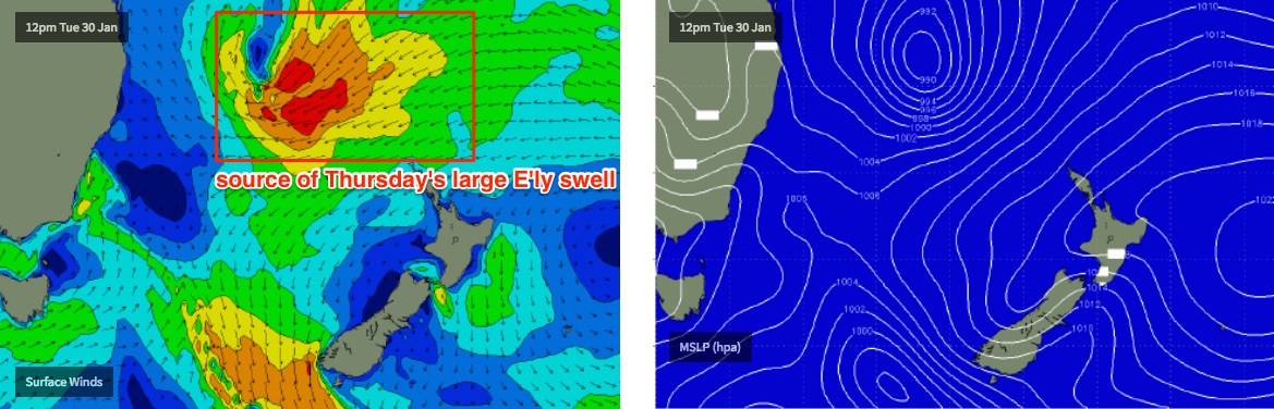
TC Fehi was named in the Coral Sea today, NW of New Caledonia. TC Fehi is tracking south and by Thursday will eventually become positioned in the central/eastern Tasman Sea as an extra-tropical system, following a merger with a broad ridge to the south, atop a large high straddling both sides of New Zealand.
Initially, Tuesday will see slowly increasing trade swell from the ridge positioned across the northern Tasman Sea. Winds will remain out of the NE but should be light as a weak trough settles across the coast ahead of a gusty S’ly change due Wednesday. We won’t see so much of a size increase as a lengthening of the swell periods, that should kick up see into the 3-4ft range throughout the day (possibly a little smaller early morning).
Wednesday morning will see a further increase in E’ly swell towards 3-5ft, though an unrelated southerly change will advance across the coast early morning, driving gusty southerly winds across all areas. This will create some problems at locations without any protection from the wind which could be well in excess of 30kts at some coasts. There's an outside chance for a brief window of light winds across the Hunter around dawn but I doubt it'll allow for much in the way of quality surfing.
The southerly change will also generate a large local S’ly swell that’ll build south facing beaches up into the 5-6ft range by late Wednesday afternoon. Conditions will however be terrible with the accompanying breeze.
As TC Fehi tracks southwards, it’ll squeeze up tight against the NZ high pressure system and reach maximum wind strength. The models have some disagreement when and there this will occur - the US model is suggesting a fast southward track with an earlier peak; the European solution delays Fehi’s forward speed and thus reaches maturity later in the week, with a subsequent later arrival time.
In any case, we’re looking at the largest peak in surf size from the east occurring some time between late Wednesday and early Friday; my money is around Thursday lunchtime (still!) where we should see a brief pulse from 4-6ft to 6ft+, maybe some bigger sets at reliable swell magnets (greater chance for this to occur south from Sydney, due to a better fetch alignment). However I am a little concerned at how fast this system may end up tracking south as it could affect the potential surf size across Southern NSW.
At the same time that the E'ly swell reaches a peak, we’ll see a rapid drop in S’ly swell through Thursday and a steady easing of S’ly wind too. Early sets may hold around 4-6ft at south facing beaches (with a few bigger sets in the Hunter) but it’ll ease throughout the day. There’s a chance for a few regions to see early SW winds on Thursday though many spots will remain bumpy under a lingering S’ly breeze.
Also, as detailed on Friday, because Thursday will display two concurrent swells (E’ly and S’ly) in the 4-6ft range, there’s a heightened chance for much larger rogue sets at times.
Light variable winds and sea breezes are then expected Friday, with steadily easing surf from the south and east (around 3-4ft from both sources).
This weekend (Feb 3rd - 4th)
In general, we’ll see wave heights continue to drop over the weekend though it should remain at quite a user-friendly level.
The merging of ex-TC Fehi and the Southern Ocean front in the Tasman Sea mid week will spin up a new fetch of S’ly gales off the SW tip of NZ on Thursday, poorly aligned for our region but sufficiently strong to maintain inconsistent 3ft+ long period sets into Saturday morning at reliable swell magnets.
Beaches with less southerly exposure will be smaller, relying on residual E/NE energy from the South Pacific.
Thursday’s low off NZ will vacate the swell window into Friday, but a north-east advancing Southern Ocean cold front just behind will maintain a small spread of south swell through Sunday, perhaps some 2-3ft sets at south facing beaches. Again, it’ll be much smaller elsewhere.
Light winds and sea breezes are expected Saturday with a S'ly change on the cards for Sunday that could generate some punchy short range energy by the afternoon.
Overall, it looks pretty fun start to the weekend across the coast - let’s reevaluate in Wednesday’s notes.
Next week (Feb 5th onwards)
Lots to keep an eye on in the longer term.
Sunday’s S’ly change is likely to become a Tasman Low of sorts, so we’ve got some good SE swell potential for the first half of the week.
A tropical depression SE of Fiji mid-late this week will remain a significant distance from the mainland but should kick up some small long period E/NE energy for the middle to latter part of next week.
Also, another tropical cyclone is expected to spin off the monsoon trough across the northern Coral Sea/tropical South Pacific later this week, and could become quite a significant system for the region - though it’s still early days as to how it may behave within our swell window.
There’s certainly lots of potential out there though.. more than enough to keep me on my toes. See you Wednesday.
Comments
That's a more optimistic forecast than I was expecting.
Fingers crossed!
Me too. There's hope
The Inverse barometer effect ?
https://m.sunshinecoastdaily.com.au/news/high-tide-rising-swell-to-flood...
Great to see a cyclone hope its one of many?
GFS has sped up the southerly track? It's all moving too damn fast.