Large, steadily easing surf from Thursday onwards

Sydney, Hunter and Illawarra Surf Forecast by Ben Matson (issued Wednesday 17th January)
Best Days: Thurs: large clean surf, easing. Fri: moderate clean surf easing, bumpy later.
Recap: It’s been big! Looks like Monday’s expectations that the models had the size trend ‘round the wrong way was, well, wrong. Tuesday delivered building S/SE swells all day with easy 8-10ft sets at exposed south facing locations by the afternoon. In general, size seems to have eased slightly across most regions this morning, however as per model guidance (and Monday’s notes) I still think there’s a chance for another similarly sized pulse some time this afternoon - model guidance has swell periods drawing out from 10 to 12 seconds, which - if it occurs - would certainly increase wave heights by a couple of feet. Anyway, winds were strong S/SW tending S’ly yesterday, easing quite a bit today and even allowing for a brief period of light W/SW winds across the Northern Beaches at dawn.
Today’s Forecaster Notes are brought to you by Rip Curl
This week (Jan 18th - 19th)
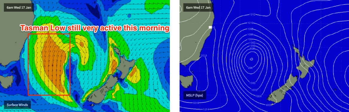
After the last few days, the next few are relatively straight forward from a forecasting point of view - it’s downwards. Continually. In fact, there are no major swell sources in the outlook so you’ll really want to capitalise on Thursday and Friday.
Fortunately, Thursday is still looking like the pick of the forecast period. We’ll see strong energy in the water - our model has 5-6ft at south facing beaches around 6am, which I still think is slightly undercooked - but winds will be light offshore early, ahead of an afternoon sea breezes, thanks to the Tasman Low weakening and moving away from the coast. I wouldn’t be surprised if there are still some lingering 6-8ft bombs at south facing beaches, though most of these will be found across the Hunter region.
Swell direction will be S/SE, so we’ll still see a wide variation in size though there’ll be strong surf at most beaches, smallest inside protected southern ends. Expect wave heights to ease by a couple of feet throughout the day.
Friday morning also looks really good though the easing trend will start to slowly speed up. I think our in-house surf model is pretty good with its size estimations - south facing beaches should manage sets around the 4ft mark early but by the afternoon we’ll be down to 2-3ft, maybe a little smaller right at the end of the day. However freshening NE winds throughout the day will confine the best surf to the early morning.
This weekend (Jan 20th - 21st)
The weekend’s troughy pattern has slipped slightly to the south in the latest model runs. This increases the chance (and strength) of likely NE winds both days, and shifts the prospects of a SE breeze to the Far South Coast, diminishing swell prospects from it too.
By this stage we’ll be down to a foot or two of weak, residual energy. Early mornings will be your best time to surf as the days will generally see freshening NE winds, so keep your expectations low.
Next week (Jan 22nd onwards)
There’s not much to get excited about at this stage.
The only long range weather system of any note is a broad tropical low that’s expected to develop east of Fiji/Samoa this weekend, and is then modelled to slowly track SW towards the northern tip of New Zealand. At such long range (and without any notable strength) its early stages are not really worth too much attention. However if it pushes closer to our region as currently forecast, we could see some E/NE swell potential for the latter part of next week and the following weekend.
Otherwise, Monday should see some NE windswell from Sunday’s local fetch, whilst a deep low passing south of Tasmania around Monday should generate a small flush of south swell mid-week. Nothing too exciting at this stage though.. tune back Friday to see if things have improved.
Comments
Swell spiking down Illawarra! :)
Maroubra jacked up again this afternoon, too!
Thanks fellas.. that's great info.
Ferk it was big n east in newy. Peaked around the 10-12 ft mark around 4pm. Sheez!!!
Few Northern Beaches points were firing yesterday, noodle arms for sure.
Great reporting Ben - Cheers!
O
Thanks Ben. The early was well worth it
Spewing had some business down in the gong today without a surfboard.
That train ride is set to breakhearts. Nothings makes me more happy than coming out of the bush on the train only to see 4-6ft sets filling the bay at Stanwell Park.
And then watching all those nice little breaks feathering inbetween peoples houses and gaps in trees..
And then the same on the way home knowing dam well that about 700 hundred breaks between there and where I'm heading would be cooking.
I'll make up for it tomorrow with that really nice high tide and a 2-5 ft swell.
All those sick beachy bowls and reforms that cater so well for a large variety of maneuvers is just what I feel like tomorrow.
And even better a nice little bit of north in the wind to help my 40+year old body try and do a AIR.
Dam train.
Woofy you must have been howling, or yelping ?