Fun waves Friday; mixed bag this weekend and next week

Sydney, Hunter and Illawarra Surf Forecast by Ben Matson (issued Wednesday 18th October)
Best Days: Thurs: building E/NE and NE swells, though local winds will spoil the party. Fri: early light winds and a peaky mix of NE and E/NE swells, easing during the day. Aim for a morning paddle before the S'ly change. Sun/Mon: small/mod mix of peaky S'ly swells with early light winds.
Recap: Tuesday delivered a peaky mix of south and east/northeast swell; the former easing overnight but the latter muscling up a little more today with 3ft sets across open beaches. Winds have however been moderate to fresh NE both days so conditions haven’t been great.
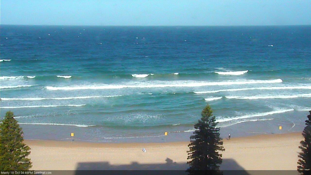
Building NE swell at Manly this afternoon
This week (Oct 19 - Oct 20)
No change to the forecast for the rest of the week.
A combination of two fetches to our north-east - a broad easterly flow through the northern Tasman Sea, plus a short north-east fetch just off our coast - will continue to generate plenty of NE swell for the next few days.
Thursday looks like a repeat of today with plenty of surf, tempered by moderate to fresh NE winds as an approaching cold front from the west tightens the pressure gradient. NE facing beaches should see 3ft sets, even the odd bigger bomb at swell magnets, but it’ll be smaller at beaches with less exposure to the north-east - this includes the Northern Hunter which is partially sheltered from these swells by the Hunter curve.
Friday morning is still the pick of the forecast period. A gusty S’ly change will reach the Far South Coast early morning, but a pre-frontal trough ahead of it will create a period of slack winds from Wollongong up into the Hunter. In fact winds may even swing light NW, though there probably won’t be enough strength to completely iron out all of the bumps from Thursday’s cross-onshore breeze.
Surf size will peak early (3ft+ sets NE swell magnets, smaller elsewhere, including the northern Hunter), and trend down during the day and the early-mid morning period will offer your only chance for a clean wave at many beaches, as the southerly is due into Sydney around lunchtime, by which time it’ll blow out exposed spots through into the afternoon.
In fact, the models have strengthened the fetch trailing the southerly change and there’s a chance for a late afternoon increase in southerly windswell to 2-3ft at south swell magnets, biggest right on dark. Quality won’t be high though.
As such aim for the early session as there should be some super fun beachies on offer, a little lumpy in places but well worth the effort.
This weekend (Oct 21 - Oct 22)
The weekend’s size prospects have increased since Monday’s outlook, but the overall forecast still isn’t especially flash.
Fresh lingering southerly winds on Saturday will largely blow out most beaches on Saturday, especially north from Sydney through the Hunter coast. We’re looking at solid 3-4ft sets at south facing beaches, easing during the day (smaller elsewhere, though bigger in the Hunter) but there are likely to be only a few locations seeing a brief window of early SW winds, and even at these spots it’ll tend S’ly by mid-morning.
However, there will be some small residual E/NE swell in the mix - also easing - offering peaky 2ft+ sets at NE facing beaches. They’ll probably be your best bet though they won’t be terribly strong and will be a little inconsistent too.
Sunday morning looks much better on the surface with light variable winds and a peaky mix of mainly easing S’ly swell plus some small E/NE leftovers. South facing beaches should manage 2-3ft sets (smaller elsewhere), and an easing trend is expected throughout the day - however the leading edge of a long period S’ly swell is expected around mid-late afternoon across the Sydney region (earlier down south).
This swell will have been generated by a deep polar low - the parent system to Friday’s change - traversing below Tasmania later Friday. It won’t be very well aligned for our region but should kick up some 3ft+ sets at reliable south swell magnets right on dark, i.e. the Hunter.
Afternoon winds will be around to the south, so this new energy may largely go to waste but it’s certainly worth keeping an eye on - I’ll take a closer look at this on Friday.
Next week (Oct 23 onwards)
Sunday’s late S’ly swell will be accompanied into Monday by a short range south swell, generated by a related fetch to the north-west of the low over the weekend. This should maintain 2-3ft+ surf at south facing beaches to start the week, and early indications are for mainly light winds.
Monday’s swell will then ease through Tuesday, and looking further ahead, there’s nothing of any great interest on the charts from the south as we head into the middle to latter part of next week.
The tropics are showing something worth rechecking again in Friday’s outlook - a broad troughy pattern through the northern Tasman Sea around Sunday and Monday - though it’s yet to model any signs of consolidation, so its swell potential is currently low. There is certainly some activity worth monitoring though, which I’ll update here on Friday.
Otherwise, local NE windswells looks like they’ll pad out the middle part of next week, ahead of a possible series of southerly swells around next weekend as a broad, slow moving trough in the Southern Ocean moves into our swell window mid-late next week. More on this in Friday’s update.
Comments
just been surfing bellambi beach . always gets the ne swells . 3/4ft some bigger .