Peaky swell mix for the coming days; large surf from a Tasman Low on Saturday

Sydney, Hunter and Illawarra Surf Forecast by Ben Matson (issued Monday 2nd October)
Best Days: Tues/Wed: peaky combo of NE swell and S'ly groundswell, with early light winds. Sat: large S/SE swell, though windy from the south. Sun: solid though easing SE swell with early light offshore winds.
Recap: Saturday saw steadily easing S'ly swell from Friday, ahead of a strong S'ly groundswell that built rapidly and peaked overnight Saturday, easing throughout Sunday. South facing beaches delivered occasional 4-6ft sets (biggest in the Hunter) but it was smaller into the afternoon and the downwards trend has continued into today. Conditions have been generally cvlean with light offshore winds through the mornings.
This week (Oct 3 - Oct 6)
Over the last few days we’ve seen strong SW swells across the SA/Vic and Tas coasts, generated by a strong succession of Southern Ocean frontal systems. Although unfavourably aligned for the NSW coast, we’ll see smaller levels of energy push along the NSW coast over the coming days, and long swell periods should bump up surf heights across south facing beaches.
In general, we’re looking at inconsistent background energy in the 2-3ft range both Tuesday and Wednesday, easing Thursday however there are a couple of embedded pulses scheduled during this time frame - one on Tuesday afternoon and another sometime Thursday - that could bump up above these figures (Tuesday’s pulse is the more certain of the two though).
As such, don’t be surprised if we see occasional 3-4ft sets at south facing beaches; this is more likely Tuesday afternoon than the morning.
Wave heights will be smaller at remaining beaches, however the Hunter should see a little more size.
Also in the mix on Tuesday and Wednesday will be a short range NE swell, generated by a local fetch off the coast. No great size is expected from this source - maybe some 2ft sets through Tuesday and possibly a few bigger waves into Wednesday - but it won’t have a lot of strength. However the combination of the south and NE swell could create some interesting peaks at the open beaches.
As for local conditions, this NE flow will create some problems away from protected northern corners but the broader synoptic flow doesn’t look like it’ll become very well established so we should see periods of slack winds through the early mornings. This will be your best time to surf.
Thursday will see an overall decrease in S’ly swell and NE windswell, though still some 2ft sets at south facing beaches and 1-2ft sets at reliable NE swell magnets early morning. The coastal trough that will have occupied the region all week is expected to slide offshore and should result in light variable winds.
But more interesting is the latest model guidance suggesting we’ll see the early incarnation of a deep Tasman Low forming east of Tasmania late Thursday. At the moment it’s hard to be confident in a notable size increase on Friday (Saturday is a safer bet for now) but the Far South and South Coasts are on target for a solid late increase in S’ly groundswell on Friday, and I wouldn’t be surprised if updated model runs shunt this arrival time forward (thus favouring the potential for a late Friday increase across the Illawarra, Sydney and maybe even Hunter coasts).
In any case, Friday’s increase will probably be accompanied by a gusty S’ly change (small residual swells with moderate SW winds prior to this) but let’s check back Wednesday to see how this system is behaving.
A very small long period S/SE swell is also possible Thurs/Fri from a polar low developing off the ice shelf (south of NZ today) but at this stage it looks like most of the fetch will form over the ice pack so swell potential is low. I’ll have a better idea on Wednesday by which time we’ll have some satellite passes. Certainly not worth worrying about too much though.
This weekend (Oct 7 - Oct 8)
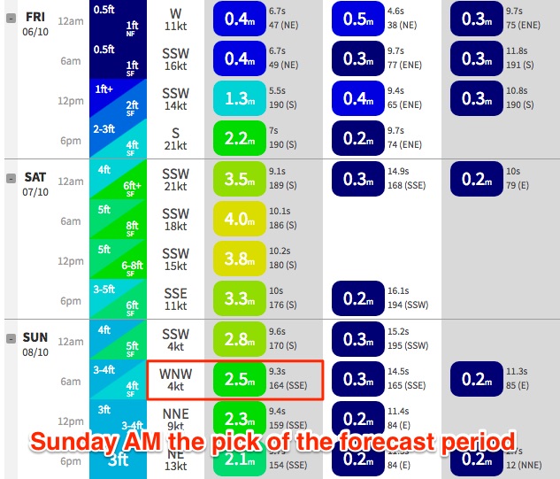
This Tasman Low is the dominant feature in the forecast charts, with a large S/SE swell on Saturday easing from the SE on Sunday. At this stage we could see solid 6-8ft surf at south facing beaches (Saturday) with bigger bombs at offshore bombies and across the Hunter coast.
Smaller though still very strong surf is likely on Sunday around 4-6ft at beaches well exposed to the south, bigger again across the Hunter. As the swell direction backs to the SE we'll see a slightly smaller size differential across the coast too. An easing trend is likely through the day.
Fresh S’ly winds will limit options to protected locations on Saturday, but Sunday - despite seeing easing size (though still solid) should produce the best waves as winds swing light offshore.
Next week (Oct 9 onwards)
There's nothing significant showing up on the long term charts for now.
Comments
Is the idea shelf near the concept rack?
Haha! Well spotted. Bloody auto spell correct.
thanks for the forecasts btw