Small residual swells for much of the week; large S'ly swells building Fri PM and Sat, easing Sun

Sydney, Hunter and Illawarra Surf Forecast by Ben Matson (issued Monday 14th August)
Best Days: Tues: small clean leftovers early, only at south swell magnets (mainly Hunter). Thurs: possibly some small new S'ly swell in the Hunter, not much elsewhere. Fri: small early, rapidly building S'ly swell in the a'noon. Sat: large S'ly swell though there's a risk of developing S'ly winds. Sun: solid but easing S'ly swell with rapidly improving conditions.
Recap: Small leftover surf persisted throughout Saturday ahead of a building S’ly groundswells on Sunday that reached 3ft at south facing beaches and up to 4-5ft across the Hunter. Wave heights eased a little into this morning but seemed to have levelled out around 2-3ft for much of the day, up to 4ft in the Hunter still. Winds have been generally light offshore.
This week (August 15th - 18th)
I’m pretty stoked to see Sunday's very tricky south swell come in on spec. It was a difficult system and could have gone either way, but fortunately we had some good satellite data on Saturday and early Sunday, confirming surface wind speeds and direction, which boosted confidence in the outlook.
The next few days looks pretty small and average. A couple of poorly aligned lows (one just south of Tasmania, the other off the ice shelf) are too zonal in structure and travelling too fast through the swell window to generate any meaningful swell for us.
Tuesday will see some small lingering S’ly swell at south facing beaches but in general will ease in size. South facing beaches may see occasional 2ft sets and it’ll be bigger across the Hunter but elsewhere there won’t be a lot of size, and the surf wil ease into the afternoon. Conditions will however be clean under a light NW breeze.
Model data has a small pulse of S/SE swell into Tuesday (swell periods increasing back to 10 seconds), but I suspect this is sourced from a small polar low over the weekend, well south of Tasmania. A quick scan of ASCAT data doesn’t show up anything of major interest, so without much time to investigate further (this swell wasn’t on the radar on Friday) I’m going to largely discount it as being anything especially worthwhile.
Wednesday looks pretty uninteresting. NE facing beaches may see a minor pulse of short range energy in the morning thanks to a broad but gusty overnight N’ly flow. South facing beaches may pick up tiny residual energy but it’s unlikely to be worth too much effort. Strengthening W/NW winds will maintain clean conditions.
Thursday will probably continue the trend of tiny clean surf and gusty offshore winds as a series of vigorous fronts track across the SE corner of the country. Strong W'ly winds exiting eastern Bass Strait Wednesday currently look like they may not have enough south in their direction to generate surf for Southern NSW, but this may change over the coming days so I'll reassess on Wednesday. At this stage I'm leaning away from there being any meaningful surf south from Sydney; the Hunter may however pick up occasional 2ft sets.
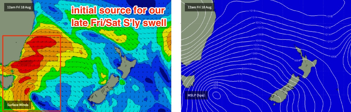
Friday is expected to deliver another funky south swell from the same acute swell window the generated yesterday’s and today’s waves. Except, this time ‘round it’ll probably be bigger thanks to a broader, stronger and more sustained fetch.
This system is quite impressive, infact we’re looking at some very large W/SW swells pushing across the central/northern Tasman Sea to New Zealand’s North Island, plus Tonga, Fiji and Samoa.
A much smaller percentage of energy will spread back into the Southern NSW coast. Again, we have to be careful with size estimations as small tweaks in the fetch’s modelled orientation between now and Thursday could dramatically influence wave heights.
But for now, we should see south facing beaches starting small around 1-2ft and holding around this size range until lunchtime, before building through the afternoon and reaching 3-5ft by the end of the day (much smaller elsewhere) and up to 5-6ft across the Hunter beaches right on dark. This swell is however expected to peak Saturday so the timing of this swell on Friday is somewhat of a wild card right now.
It’ll be quite blowy with gusty W/SW winds on Friday but at this stage it looks like there will be no shortage of surf to finish the working week.
This weekend (August 19th - 20th)
Stronger secondary fronts rounding the Tasmanian corner on Friday - still a part of the same broader system exiting into the Tasman Sea from late Thursday - will generate a better aligned S/SW fetch that will contribute bigger swells into Saturday.
The main risk we have on Saturday is that these fronts will also track up the coast, bringing a S’ly change to the coastal strip. However in doing so they’ll also kick up wave heights.
Right now expectations are for early W/SW winds and 4-5ft surf at south facing beaches (much smaller elsewhere, but up to 6-8ft in the Hunter), building by another foot or two throughout the day, albeit with dicey winds. However this large southerly swell combo should favour good waves at protected southern ends, albeit much smaller in size.
Rapidly easing swells and winds are then expected on Sunday - still quite solid through the morning, and probably still wind affected at some exposed coasts (i.e. Hunter) but otherwise improving quickly.
Next week (August 21st onwards)
More mid-latitude lows for next week and more south swell! But we’ve got more interesting things to focus on in the short term so let’s take a closer look on Wednesday.
Comments
Couple of clean baby NE windswell peaks across Manly this AM.