Tricky south swells Thurs/Fri; great surf expected next week

Sydney, Hunter and Illawarra Surf Forecast by Ben Matson (issued Wednesday 14th June)
Best Days: Thurs/Fri: both days have potential with new S and then S/SE groundswells, and light winds. Later Mon/Tues/Wed: strong E'ly groundswell, good winds mid-week.
Recap: We’ve seen small swells and light winds for the last few days. A new S’ly groundswell later this afternoon has yet to show properly across the buoy network though there are some bigger waves visible on some of the surfcams, however it doesn’t appear to be the new groundswell.
This week (Jun 15 - 16)
 We have a tricky couple of days ahead.
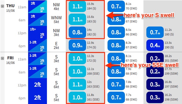
A new S’ly groundswell due to arrive later today and then peak through Thursday is sourced from a tricky, unfavourably aligned front that pushed through the lower Tasman Sea earlier this week. However, model guidance is usually not particularly reliable from these systems so the fact that WaveWatch III is estimating up 1.1m at 15-16 seconds (off the Northern Beaches) in the early hours of Thursday morning - which our surf model is translating to 3ft sets at south facing beaches - is very encouraging indeed.
If anything I should be using prior experience as a guidance and increasing my own forecast well above this figure, but I simply can’t see there being much more size than this from such a poorly aligned (though quite powerful) fetch.
The fact that there’s not much showing now is of no great concern because the initial timing of the swell fronts from these events is not always spot on, and the latest model guidance has slightly shifted the leading edge back overnight anyway.
So right now there’s no available data that can be used as a justification to downgrade Monday’s estimate for Thursday (3ft+ south facing beaches, slightly bigger in the Hunter but much smaller elsewhere). Winds will be light offshore for much of the day so conditions will be clean. Set waves will be quite inconsistent, so just hit up your favourite south swell magnet for the best options.
This swell will then ease through Friday however Craig picked up a small source of new SE swell that I missed in Monday’s notes - a deep polar low south of New Zealand earlier in the week (the dynamic Tasman charts must have swayed my attention from the remote southern latitudes).
Again, model guidance is rather strong with just over a metre at 12 seconds from the S/SE on Friday, which should in theory translate to 2-3ft at some south facing beaches. However these SE swells are equally flukey and the large travel distance will probably create very inconsistent set waves. Light variable winds are expected so again conditions will be clean.
Elsewhere, a stationary ridge through the northern Tasman Sea - that’s generated a couple of days of sizeable waves in SE Qld and Far Northern NSW - should also produce a small spread of E/NE swell across the Sydney region. Not much, but probably enough to see occasional 2ft sets at most open beaches building through Thursday and Friday.
This weekend (Jun 17 - 18)
Freshening southerly winds are expected all weekend as a trough along the East Coast strengthens.
Initially, Saturday morning should be OK with light winds from the SW but they’ll swing S’ly throughout the day and Sunday looks at this stage to be a write off with gusty winds.
Unfortunately, Saturday morning’s better conditions will be accompanied but a decreasing swell trend from the S/SE. South facing beaches (mainly the Hunter) may see early 2ft+ sets but it’ll become smaller during the day. A small E/NE swell will also be present in the water (occ 2ft sets) from the fetch up north but no great surf is likely from this source either.
Sunday will see conditions deteriorate as the southerly picks up strength. We will see a concurrent increase in short range windswell, though only south facing beaches will pick up and size and they’ll be choppy.
The E/NE infeed into the trough will muscle up across the Tasman through Saturday so at some point on Sunday we’ll see bigger surf from this source, though Monday, Tuesday and Wednesday are looking at seeing the most size. But I’ll reevaluate this on Friday with the availability of better data.
Next week (Jun 19 onwards)
The models have moved around a little since Monday’s notes. And interestingly, the area I wanted to keep a watch on - the eastern flank of the Tasman trough - is now expected to swing in our favour. The approaching LWT is now likely to have less influence so we’re looking at a broad trough across the entire Tasman Sea, with several fetches generating surf for us.
Monday will see more E/NE swell from the troughy infeed, plus some even more short range S’ly swell from local fetch. But a developing low at the southern end of the trough will strengthen E’ly winds immediately east of Sydney on Sunday and this will persist through Monday and Tuesday, generating a strong mid-range E’ly groundswell that will build through Monday and then broadly plateau into Tuesday and Wednesday.
At this stage I’m still hesitant to be confident on a likely size range, because the models have been rather erratic in recent days - but is looks like we could see a day and a half (or more) of 5-6ft surf across most open beaches. If the models ramp up wind speeds, expect this estimate to be revised upwards.
Otherwise, there are a couple of small long period south swells expected next week but nothing of any great size.