Plenty of surf ahead; strong from the south early next week

Sydney, Hunter and Illawarra Surf Forecast by Ben Matson (issued Wednesday 11th January)
Sign up to Swellnet’s newsletter and receive the Sydney, Hunter and Illawarra Forecaster Notes and latest news sent directly to your inbox. Upon signup you'll also enter the draw to win a surf trip to P-Pass for you and a mate. It doesn’t get much easier so click HERE to sign up now.
Best Days: Thurs/Fri: small mix of swells, tricky winds though. Sat: early peak in NE windswell and light W'ly winds. Sun: solid S'ly swell. Mon/Tues: solid S'ly swell with light winds and sea breezes.
Recap: Small, small small from the NE. And hot. But mainly small.
This week (Jan 12th - Jan 13th)
The southerly change pushing up the coast is tracking a little ahead of expectations and should offer some cool relief across the Sydney coast this evening. A very small low may form along the trough line early Thursday morning - somewhere east of about Seal Rocks - but it’ll be short lived and won’t be much of a swell producer for us.
However, two fetches related to this change - much further south - should kick up a series of small south swells for Thursday and Friday. There won’t be much depth to the fetch trailing tonight’s change, but a small W/SW fetch exiting eastern Bass Strait this afternoon should be worthy of a small small waves up to 2ft across south facing beaches by Thursday afternoon and into Friday morning.
Otherwise, a deep low tracking south of Tasmania today hasn’t changed its predominantly zonal flow through the Southern Ocean, so there’s no change to the possibility of a few stray 1-2ft sets from this source glancing the coast through Thursday afternoon and Friday too.
Either swells are not high confidence but there should be some little waves as a minimum at the swell magnets.
Also in the water over the next few days will be a minor NE windswell early Thursday (from a stationary but departing N’ly fetch off the Mid North Coast today), plus some small E/NE trade swell both days, originating from a minor trade wind positioned north of New Zealand. I doubt we’ll see much more than a foot or two from these sources, and set waves will be extremely inconsistent.
As for local conditions, tonight’s S’ly change won’t last long and will quickly abate through Thursday morning, in fact we should see early W/SW winds at many beaches, especially those south of Sydney. If anywhere, there’s a chance for a lingering S’ly breeze across the Hunter but we should see variable winds develop through the middle of the day, tending light to moderate onshore in the afternoon.
On Friday, a brief period of early light NW winds will give way to a strengthening NE breeze that should reach 20kts+ into the afternoon. This should also whip up a low quality NE windswell through the afternoon up to 2ft, possibly 2-3ft at reliable swell magnets close to dark, but quality won’t be high.
This weekend (Jan 14th - 15th)
The models have slightly strengthened the NE fetch off the Hunter/Mid North Coast on Friday afternoon and evening, and with some luck the associated swell increase will persist into Saturday morning.
A light W’ly change associated with an approaching low pressure system below the continent will clean up conditions for the morning session, but the offshore fetch will retreat out of our swell window by dawn so there’ll be an easing trend in the size department all day. Let’s hope it doesn’t begin before sunrise.
At this stage reliable NE swell magnets should see some 2-3ft sets, of which there’ll be a tiny underlying E/NE swell and possibly some small residual S’ly swell around a foot or so. But the NE windswell is the energy we’ll be targeting on Saturday. Expect easing size throughout the day.
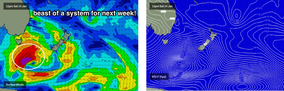
The deep Southern Ocean low will finally push into our swell window on Saturday. The proper groundswell from this system will still be a few days away, but we’ll see a building mix of short and mid range S’ly windswell on Sunday that should reach 4-5ft at south facing beaches.
Local winds look a little dicey - a moderate to fresh S’ly breeze is likely - though the synoptic pattern probably won’t be so great as to not allow for a period of early SW winds in some areas. However, the middle of the day and the afternoon is when we’re expecting to see the most size so the early surf - although cleaner - may be a little smaller.
Regardless, there are a few halfway decent options on tap for the weekend so let’s see how the models are panning out on Friday.
Next week (Jan 16th onwards)
Long period S’ly groundswell from the Southern Ocean low is expected to fill in through Monday and Tuesday.
It’s still unclear how much size we’ll see and when it'll peak, as this system is moving around in the model runs, but it’s showing signs of some very good quality surf, possibly between 4ft and maybe 6ft range at south facing beaches and even bigger across the Hunter and at offshore bombies (owing to the longer swell periods).
Note: this is a somewhat optimistic outlook, and is higher than our internal model is calling (currently 3-4ft early Tuesday) but I have a suspicion that an upgrade is likely over the coming days. Local winds look good right now too, mainly light and variable with sea breezes both days.
Otherwise, there are no other major swell systems on the boil for the longer term period. See you Friday!
Comments
The S'ly change is now on the Coal Coast; ahead of it E/NE winds are gusting 37kts (!) at Wattamolla.
Should be into Cronulla shortly, then the Northern Beaches before 6pm.
Just arrived in Cronulla now!
Great to see some swell in the forecast, but shame it wont be really turning up till Monday. The weekend sounds fun anyway and it sure has been a quiet summer so far in the swell department. Gotta wonder though, when the fark are we going to see some tropical low development and E - NE swell action!? P.S Love ya work Ben!
Peaky sets at Bondi, nothing amazing but certainly a few little waves.
A cracking good pulse in the solid 3'+ range came in on the high tide this morning, and was really good for a couple of hours before the wind turned more nor east. The earlier report from up here of 2' and weak was over-selling it a bit, but it sure turned around. Some longer period in that mix too.
I'm thinking of the recent southerly system which was forecast to form a small band of very strong south easterly winds from just under and west of NZ south Island a day or two ago.
Not sure if it's still around, but so pleasantly surprised. A good time was had by all who were lucky enough to find it.
Did that show up on the bouys Ben?
Interesting, nah it didn't just dropping S'ly swell and building NE swell (swing in direction).
Friday update coming ben??? Wams look to have weakened a little for sunday -tuesday maybe?
Thanks Craig, definitely not a north east swell, was here well before the wind at a location that picks up the south swells, and a strong pulse, nothing like the rubbish wind swell that we have been getting of recent times.